Prithla Masterplan 2031: DTCP Zone Check and Land Use Guide
Prithla Masterplan Preview
Try the Prithla Masterplan 2031 on the map
Sign in once and explore the layer for a full day.
- No card details needed
- Find nearby verified lands for sale
Overview
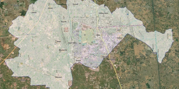
The Prithla Masterplan 2031 is the Final Development Plan (FDP) prepared by the Department of Town and Country Planning (DTCP), Haryana, governing the controlled area of Village Prithla and adjoining regions in District Palwal. Implemented in 2011 and valid through 2031, the plan divides Prithla into 13 sectors covering residential, industrial, commercial, and green belt zones. Buyers must verify their survey number against this plan before any purchase. This page covers zone classifications, regulatory traps, and the key corridors where the Prithla Masterplan 2031 directly affects land value and legal buildability.
Zone Trap: Why 12 of 13 Sectors in Prithla Cannot Have Residential Construction
The single biggest mistake buyers make in Prithla is purchasing a plot in an industrial or utility sector assuming a CLU (Change of Land Use) approval is easy to obtain. It is not. The Prithla FDP 2031 designates Sector 6 as the only residential sector across the plan's 13 sectors. Every other sector is zoned primarily for industrial, commercial, green belt, or public utility use.
This table shows the functional zone breakdown as documented in the Prithla FDP 2031 and corroborated by DTCP Haryana records.
Zone Type
Sectors
Buildable for Residential?
CLU Required?
Residential
Sector 6 only
Yes, directly
No
Industrial
Multiple sectors
No
Yes, from DTCP Haryana Director
Green Belt / Public Utility
Multiple sectors
No
Not permitted
Commercial
Designated pockets
Only for commercial use
Yes
Zone Type
Sectors
Buildable for Residential?
CLU Required?
Residential
Sector 6 only
Yes, directly
No
Industrial
Multiple sectors
No
Yes, from DTCP Haryana Director
Green Belt / Public Utility
Multiple sectors
No
Not permitted
Commercial
Designated pockets
Only for commercial use
Yes
Any plot sold outside Sector 6 with a claim of residential buildability should be cross-checked on the DTCP Haryana portal before signing anything. In Haryana, the CLU application process takes 60 to 90 days when documents are complete, and approval is not guaranteed: DTCP operates under Punjab Scheduled Roads and Controlled Areas Restriction of Unregulated Development Act, 1963, which allows the government to refuse any CLU that conflicts with the operative development plan. Illegal colonies built without DTCP licence face demolition; the department has executed demolition drives across Haryana NCR districts, and Palwal is within its enforcement jurisdiction. If a broker cannot show you both the FDP zone map and a DTCP licence number, that plot is unverified.
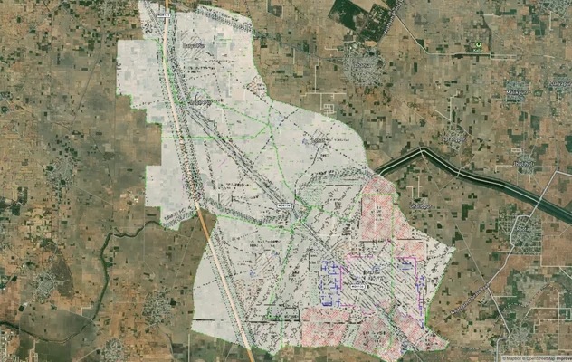
Sector 6 and the Industrial Corridor: Where the Prithla Masterplan 2031 Creates Real Value
Prithla's land market breaks into two clear investment profiles. Sector 6 is investable for residential buyers. The industrial corridor running through the plan's remaining sectors is the engine behind that residential demand.
Here is how the key corridors in the Prithla Masterplan 2031 affect land decisions today.
Corridor / Locality
Zone
Growth Driver
Known Risk
Sector 6, Prithla
Residential (DDJAY licensed)
Only residential sector; 500+ industries driving worker housing demand
Limited supply, high broker activity
Prithla Industrial Area
Industrial
500+ large industries operating; DFC (Dedicated Freight Corridor) alignment nearby
No residential buildability without CLU
NH-19 / Mathura Road Frontage
Mixed commercial fringe
Connectivity to Delhi, Faridabad, Palwal, and 35 km from Jewar International Airport via Ballabgarh–Jewar link
Highway-adjacent plots need CLU for warehouse or commercial use
Eastern Agra Canal Corridor
Urbanisable area (Faridabad FDP linkage)
75-metre and 90-metre roads proposed to connect Prithla to Noida and Greater Noida
Roads not yet built; valuation is speculative until notification
The most misunderstood corridor is the Agra Canal fringe. The connectivity to Noida and Greater Noida is proposed in the Faridabad Master Plan 2031, not yet executed. Buyers quoting Jewar Airport proximity as a reason to buy agricultural land on this fringe are pricing in an infrastructure event that may still be years away from physical delivery. Sector 6 land, by contrast, has an active DTCP licence, existing rental demand from industrial workers, and the only legal path to residential construction within the Prithla controlled area today.
Was this layer helpful?
Anything wrong, outdated, or missing we want to hear it.
For Land Owners & Agents
Looking to sell your land in Delhi?
I want to sell my land in Delhi
10:32
Plz share your Land's location - We will list it on 1acre map, for Free.
10:32

For Land Buyers
Browse all verified lands & plots in Delhi NCR
Every listing goes through our Preliminary Verification Process.
More Layers in Delhi NCR
See all 30 layers
Alwar UIT Masterplan 2031: Zone Check and Land Use Guide
View Alwar Masterplan as a live map overlay – check any plot's land use zone for free on 1acre.in. Alwar Master Plan 205...
Arogya Dham Badsa Masterplan: Zone Check and Land Use Guide
View Arogya Dham Badsa Masterplan as a live map overlay – check any plot's land use zone for free on 1acre.in. Arogya Dh...

Baghpat Baraut Khekra Masterplan: Zone Check and Land Use Guide
View Bhagpat-Baraut-Khekra Masterplan as a live map overlay – check any plot's land use zone for free on 1acre.in. Baghp...
More Layers in Delhi NCR
Alwar UIT Masterplan 2031: Zone Check and Land Use Guide
View Alwar Masterplan as a live map overlay – check any plot's land use zone for free on 1acre.in. Alwar Master Plan 205...
Arogya Dham Badsa Masterplan: Zone Check and Land Use Guide
View Arogya Dham Badsa Masterplan as a live map overlay – check any plot's land use zone for free on 1acre.in. Arogya Dh...
Baghpat Baraut Khekra Masterplan: Zone Check and Land Use Guide
View Bhagpat-Baraut-Khekra Masterplan as a live map overlay – check any plot's land use zone for free on 1acre.in. Baghp...