Dharuhera Masterplan 2031: DTCP Zone Check and Land Use Guide
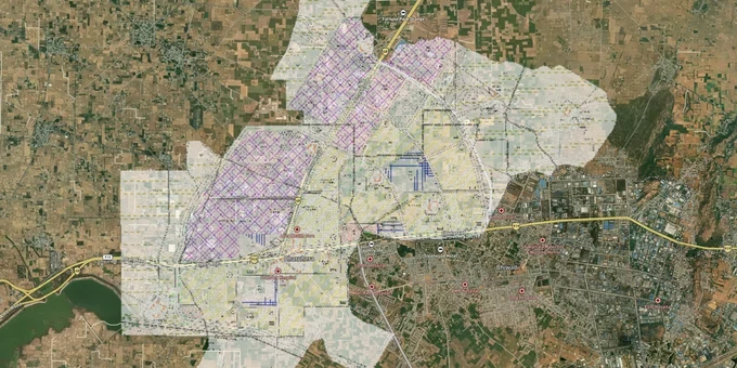
Dharuhera Masterplan Preview
Try the Dharuhera Masterplan 2031 on the map
Sign in once and explore the layer for a full day.
- No card details needed
- Find nearby verified lands for sale
Overview
The Dharuhera masterplan 2021 is the Integrated Final Development Plan (FDP 2021) prepared by the Department of Town and Country Planning (DTCP) Haryana, notified on 28 December 2007 under the Punjab Scheduled Roads and Controlled Areas Restriction of Unregulated Development Act, 1963. It covers a total urbanisable area of 1,900 hectares across 17 planned residential sectors, industrial, commercial, and open space zones, plus an agricultural controlled area beyond the urbanisable limits. Dharuhera sits 72 km from Delhi on NH-48 and 27 km from Gurugram. This page covers the zone traps that end transactions, the corridors where confirmed demand exists, and how to verify before committing.
Green Belt Encroachment and Unlicensed Colonies: The Dharuhera FDP 2021 Risks That Wipe Out Investments
Two zone violations account for the majority of failed purchases in Dharuhera's controlled area: buying agricultural land near the NH-48 green belt without a valid CLU, and purchasing plots inside unlicensed colonies that lack a DTCP licence number. Both look like straightforward residential purchases until due diligence begins.
The table below maps Dharuhera's five FDP 2021 zone types to their development rights and primary risk.
Zone
Permitted Use
Requires CLU?
Primary Trap
Residential (17 Sectors)
Housing per sectoral plan; medium and high density
No, if within notified sector boundary
Unlicensed plotted colony adjacent to planned sector sold without DTCP licence; banks refuse loans
Commercial (87 ha: Sectors 2, 5-B, 20)
Retail, district shopping centres (56 ha); wholesale trade, warehousing, godowns (31 ha)
No, if within notified commercial zone
Agricultural land adjacent to wholesale zone sold as commercial-convertible; no CLU issued
Industrial (626 ha along NH-48)
Manufacturing, engineering, chemicals; non-polluting only per FDP
No, within notified industrial zone
Peripheral industrial plots marketed to residential buyers near Hero MotoCorp gate
Agricultural Zone (Controlled Area outside 1,900 ha)
Farming; essential village construction only
Yes: Form CLU-I to Director DTCP; Rs 10/sq mtr scrutiny fee for residential use
Sold as "upcoming residential sector" with no CLU on DTCP portal; no utility connections available
Open Space and Green Belt (174 ha; 60m buffer on NH-48, 45m on State Highway)
Town Park Sector 7A: 45 ha; neighbourhood and sector parks; no private construction
Not applicable
Marketed as "park-facing plot" or farmhouse land; building plan sanction legally impossible
The green belt on NH-48 is the single most misrepresented zone in Dharuhera. The FDP 2021 reserves a 60-metre buffer on both sides of NH-48 (formerly NH-8) as an arterial green belt. No building plan can be sanctioned within this buffer, and no CLU converts it to another use. The 45-hectare Town Park in Sector 7A is the largest open space in the plan. Land immediately adjacent to it carries planning value, but the park itself is reserved land.
For unlicensed colonies, the rule is direct: no bank in India will approve a home loan for a plot inside a colony without a valid DTCP licence number. Under Haryana Building Code 2017 and DTCP policy, a building plan sanction for a Low Risk Category structure (under 15 metres, residential) in an area without CLU or DTCP licence can be issued under self-certification, but the underlying land use violation remains. That means the building exists; the legal status of the land does not change. Verify the DTCP licence number on tcpharyana.gov.in before signing anything.
NH-48 Sectors, the DMIC Belt, and Sector 7A: Separating Real Demand from Corridor Speculation in Dharuhera
Dharuhera's demand story is genuine, but it is geographically concentrated. The industrial anchor is confirmed: Hero MotoCorp, Amul, Carlsberg, Honda Motorcycle, Lumax Industries, Jaquar Sanitaryware, Gillette India, and United Breweries all operate here. Residential plot prices moved from Rs 20,000 per sq yard in 2019 to Rs 65,000-70,000 per sq yard by 2025. The question is not whether demand exists; it is whether a specific parcel sits in a zone that captures it.
The table below maps the three demand corridors in Dharuhera to their FDP 2021 designations and confirmed infrastructure status.
Corridor
Active Sectors
FDP 2021 Zone
Infrastructure Anchor
Risk Level
NH-48 Residential Belt
Sectors 5, 6, 7, 7A, 19, 22, 23, 24
Residential zone; 725 ha at 300 persons per hectare
Proximity to industrial estate employment; DDJAY scheme plots active
Low to Medium; confirm DTCP licence number for every plotted colony
Industrial Estate and DMIC Belt
Sectors 16-18 industrial; DMIC Dharuhera-Manesar-Bawal-Rewari corridor
Industrial zone (626 ha); DMIC Highway Corridor Zone in NCR Plan 2041
DMIC Dharuhera node included in NCR Plan 2041; Bharatmala 28 km feeder route Dharuhera-Sohna planned
Medium; industrial land cannot receive residential CLU
Wholesale Commercial and Transport Zone
Sectors 2, 5-B, 20; 38.5 ha truck parking in Sector 18
Commercial zone (87 ha) + Transport zone (251 ha)
NH-48 and Palwal-Sohna-Rewari road junction; proposed Khurja-Palwal-Sohna-Rewari-Jhajjar railway alignment
Medium-High for retail buyers; wholesale and transport zone designations limit residential conversion
The most misread corridor is the DMIC belt. Dharuhera is included in the Gurugram-Manesar-Bawal-Dharuhera-Rewari Highway Corridor Zone under the Delhi NCR Masterplan 2041, and the DMIC project prioritises this region for manufacturing expansion with a completion target of 2032. That is a real designation with funded infrastructure behind it. What it does not do is change the zone of agricultural land between the highway and the industrial estate. Agricultural parcels within the controlled area remain agricultural until a specific CLU is issued by the Director, DTCP Haryana. A DMIC corridor designation in the NCR Plan is not a CLU.
For residential buyers, Sectors 7, 7A, 19, and 24 are the zones where confirmed licensed-colony inventory exists on NH-48, and where bank loans are available. Plot sizes under DDJAY (Deen Dayal Jan Awas Yojana) in Dharuhera start from 100 sq yards with RERA registration. These are the parcels to compare against before looking at cheaper agricultural land adjacent to the industrial area.
Was this layer helpful?
Anything wrong, outdated, or missing we want to hear it.
For Land Owners & Agents
Looking to sell your land in Delhi?
I want to sell my land in Delhi
10:32
Plz share your Land's location - We will list it on 1acre map, for Free.
10:32

For Land Buyers
Browse all verified lands & plots in Delhi NCR
Every listing goes through our Preliminary Verification Process.
More Layers in Delhi NCR
See all 30 layers
Alwar UIT Masterplan 2031: Zone Check and Land Use Guide
View Alwar Masterplan as a live map overlay – check any plot's land use zone for free on 1acre.in. Alwar Master Plan 205...
Arogya Dham Badsa Masterplan: Zone Check and Land Use Guide
View Arogya Dham Badsa Masterplan as a live map overlay – check any plot's land use zone for free on 1acre.in. Arogya Dh...

Baghpat Baraut Khekra Masterplan: Zone Check and Land Use Guide
View Bhagpat-Baraut-Khekra Masterplan as a live map overlay – check any plot's land use zone for free on 1acre.in. Baghp...
More Layers in Delhi NCR
Alwar UIT Masterplan 2031: Zone Check and Land Use Guide
View Alwar Masterplan as a live map overlay – check any plot's land use zone for free on 1acre.in. Alwar Master Plan 205...
Arogya Dham Badsa Masterplan: Zone Check and Land Use Guide
View Arogya Dham Badsa Masterplan as a live map overlay – check any plot's land use zone for free on 1acre.in. Arogya Dh...
Baghpat Baraut Khekra Masterplan: Zone Check and Land Use Guide
View Bhagpat-Baraut-Khekra Masterplan as a live map overlay – check any plot's land use zone for free on 1acre.in. Baghp...