Nuh Masterplan 2031: DTCP Zone Check and Land Use Guide
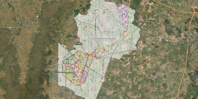
Nuh Masterplan Preview
Try the Nuh Masterplan 2031 on the map
Sign in once and explore the layer for a full day.
- No card details needed
- Find nearby verified lands for sale
Overview
Nuh Masterplan 2031 is the Final Development Plan (FDP) published by the Director, Town and Country Planning, Haryana (DTCP) under the Punjab Scheduled Roads and Controlled Areas Restriction of Unregulated Development Act, 1963. It governs land use across Nuh district, covering 1,507 sq km in the NCR, bordering Gurugram to the north. Most land in the controlled area remains designated as agricultural zone. Any non-agricultural construction, including residential, commercial, or industrial, requires a Change of Land Use (CLU) permission from DTCP before development begins.
Why the Agricultural Zone Designation in Nuh Masterplan 2031 Catches Buyers Off Guard
Nuh sits in NCR and shares a border with Gurugram, so buyers routinely assume that proximity to India's richest district means similar development rights. It does not. NITI Aayog listed Nuh as India's most underdeveloped district in 2018. As of the FDP 2031, the overwhelming majority of land in the controlled area is agricultural zone. Buying agricultural land and building on it without a valid CLU permission is illegal under the 1963 Act, regardless of what a broker says about "NCR land" or "expressway corridor plots."
CLU Process and Zone Restrictions Under Nuh DTCP Masterplan 2031
In Haryana, CLU applications in the controlled area go to the District Town Planner and ultimately to the Director, DTCP Chandigarh. The process involves submission of Form CLU-I, shajra plan, survey plan showing 100 yards surrounding context, sale deed, and a land utilisation plan. Importantly, government can relax zoning regulations under Section 7(A) of the 1963 Act only in public interest and only in exceptional circumstances. A broker claiming "relaxation is routine" is misrepresenting the process. The table below sets out the main zone categories and what each permits without CLU in the Nuh controlled area.
Zone
Permitted Without CLU
Requires CLU?
Common Misrepresentation
Agricultural Zone
Farming, farm houses (as per policy)
Yes, for any residential / commercial / industrial
Sold as "plotted development land"
Residential Zone
Housing (in licensed colony with DTCP approval)
Colony licence required from DTCP
Unlicensed "approved plots" claims
Industrial Zone
Industry as per zoning regulations
CLU for non-conforming uses
"Industrial" sold as mixed-use
Transport and Communication Zone
Transport infrastructure only
Yes, for other uses
Roadside plots sold as commercial
Post the July 2023 violence in Nuh, the Punjab and Haryana High Court on August 7, 2023 called the state's five-day demolition drive "an exercise of ethnic cleansing" and issued interim orders to halt further demolitions. Over 1,200 structures across Tauru, Nuh town, Nalhar, Nagina, and Ferozepur Jhirka were razed, including structures with valid title deeds and settled possession. The High Court order is a direct signal to land buyers: title deed alone does not protect a structure in Nuh if underlying land-use compliance is absent or disputed.
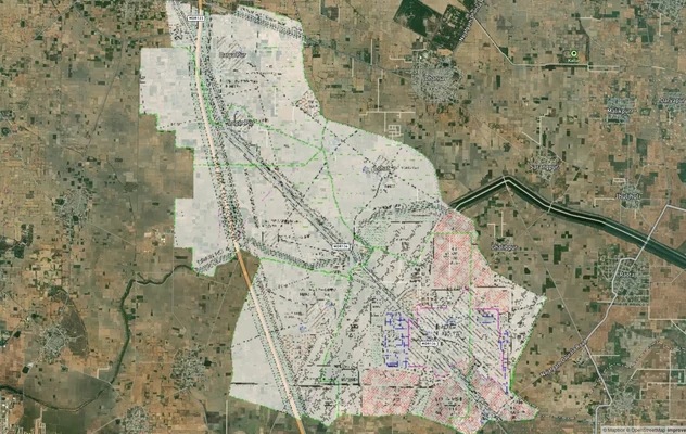
Tauru, Nalhar, Ferozepur Jhirka and the Delhi-Mumbai Expressway Belt: Where Infrastructure Demand Meets Zone Risk
Nuh district is now crossed by two of India's most significant infrastructure corridors. The KMP (Kundli-Manesar-Palwal) Expressway runs through the northern fringe of the district via Tauru, and the Delhi-Mumbai Expressway (Section 2) passes through Nuh district touching Bhirawati, Khalilpur, Ferozepur Jhirka, and Pinangwan before entering Rajasthan. Industrial demand has grown sharply in the Tauru sub-division, driven by its proximity to IMT Sohna along the KMP corridor on the Sohna-Nuh Road. Most of the Nuh land market, though, remains agricultural. Expressway proximity does not automatically confer development rights.
The table below maps the sub-divisions and corridors buyers most actively target and the key risk in each.
Corridor / Locality
Sub-division
Primary Zone
Key Driver
Known Risk
Tauru
Taoru
Mixed: residential / agricultural / industrial fringe
KMP Expressway, proximity to Gurugram
High land price relative to underdeveloped infrastructure
Nalhar
Nuh
Agricultural zone
Nalhar Mahadev temple pilgrimage, Delhi-Mumbai Expressway alignment
2023 demolition drive; High Court proceedings ongoing
Ferozepur Jhirka
Ferozepur Jhirka
Agricultural / industrial fringe
Delhi-Mumbai Expressway passes east of town
Demolition drive; disputes over settled possession vs encroachment
Rewasan
Nuh
Agricultural zone
Affordable pricing, NCR tag
No scheduled infrastructure within ward boundary
Punahana
Punahana
Agricultural zone
Agricultural base, farmland demand
Weak urban amenity, no HUDA sector development
Indari
Nuh
Agricultural zone
Residential plot listings active
No DTCP-licensed colony confirmed
Tauru is the most misread corridor in Nuh. Buyers see KMP Expressway access and Gurugram proximity, and brokers pitch it as the next Manesar. But IMT Sohna's 1,500 acres of HSIIDC land is on the Sohna side of the KMP, not inside Nuh district. Tauru plots priced on that industrial narrative still require DTCP CLU if they are agricultural zone land, and the 20 km from Gurugram does not make them residential by default. Verify the zone on the FDP map at tcpharyana.gov.in before paying any advance.
Was this layer helpful?
Anything wrong, outdated, or missing we want to hear it.
For Land Owners & Agents
Looking to sell your land in Delhi?
I want to sell my land in Delhi
10:32
Plz share your Land's location - We will list it on 1acre map, for Free.
10:32

For Land Buyers
Browse all verified lands & plots in Delhi NCR
Every listing goes through our Preliminary Verification Process.
More Layers in Delhi NCR
See all 30 layers
Alwar UIT Masterplan 2031: Zone Check and Land Use Guide
View Alwar Masterplan as a live map overlay – check any plot's land use zone for free on 1acre.in. Alwar Master Plan 205...
Arogya Dham Badsa Masterplan: Zone Check and Land Use Guide
View Arogya Dham Badsa Masterplan as a live map overlay – check any plot's land use zone for free on 1acre.in. Arogya Dh...

Baghpat Baraut Khekra Masterplan: Zone Check and Land Use Guide
View Bhagpat-Baraut-Khekra Masterplan as a live map overlay – check any plot's land use zone for free on 1acre.in. Baghp...
More Layers in Delhi NCR
Alwar UIT Masterplan 2031: Zone Check and Land Use Guide
View Alwar Masterplan as a live map overlay – check any plot's land use zone for free on 1acre.in. Alwar Master Plan 205...
Arogya Dham Badsa Masterplan: Zone Check and Land Use Guide
View Arogya Dham Badsa Masterplan as a live map overlay – check any plot's land use zone for free on 1acre.in. Arogya Dh...
Baghpat Baraut Khekra Masterplan: Zone Check and Land Use Guide
View Bhagpat-Baraut-Khekra Masterplan as a live map overlay – check any plot's land use zone for free on 1acre.in. Baghp...