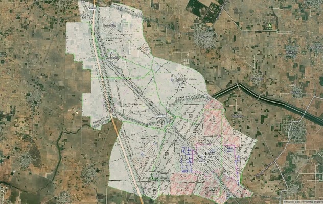
Hodal Masterplan 2031: DTCP Zone Check and Land Use Guide
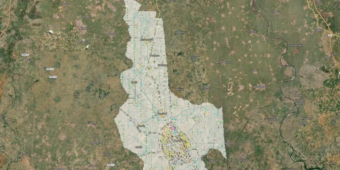
Hodal Masterplan Preview
Try the Hodal Masterplan 2031 on the map
Sign in once and explore the layer for a full day.
- No card details needed
- Find nearby verified lands for sale
Overview
The Hodal Masterplan 2031 land buying decision starts with one question: what zone is your khasra number in? Prepared by the Directorate of Town and Country Planning (DGTCP) Haryana under the Punjab Scheduled Roads and Controlled Areas Restriction of Unregulated Development Act, 1963, this plan governs land use across Hodal town in Palwal District. Hodal sits 88 km from Delhi on NH-44 (formerly NH-2) and is classified as a Medium Potential Zone town under Haryana's urban hierarchy. This page covers the zone codes, CLU requirements, and the corridors where land values are actively moving.
CLU and Zone Traps Buyers in Hodal Miss Until It's Too Late
The single biggest risk in Hodal is buying land in the agricultural zone and assuming it can be converted later. The DGTCP issues CLU (Change of Land Use) permissions under Section 26-A of the zoning regulations, but approval is not automatic: it requires a Shajra plan, khasra/Shajra plan, land utilization plan, and a scrutiny fee of applicable scrutiny fee for residential or commercial use. More critically, the Haryana government has explicitly prohibited industrial units in the agricultural zone of medium- and high-potential towns, and applications are approved only in conformity with the published zoning regulations.
The table below shows the primary regulatory traps buyers encounter in Hodal's controlled area.
Risk
What It Means
What to Verify
Agricultural zone plot marketed as "convertible"
CLU is not guaranteed; DGTCP must approve it
Check zoning on the published FDP 2031 map before signing any agreement
NH-2 highway-touch land in green/orange zone
Warehouse and industrial CLU possible, but residential CLU is typically rejected
Confirm proposed use matches permitted use in the zone
Colony without DGTCP license
Development in controlled area without a license is illegal under the 1963 Act
Ask for the coloniser's license number issued by DGTCP
Shajra not matching sale deed boundaries
Revenue records and plan boundaries frequently diverge in Palwal district
Obtain a current Shajra plan from the Patwari before registration
If a broker cannot produce the DGTCP FDP 2031 zone map for your khasra number, walk away before signing the token amount.
Hodal Land Corridors: NH-2 Front vs. Interior Village Land
Hodal's land market splits cleanly into two tiers: highway-facing plots on NH-44 and interior agricultural parcels. The first tier attracts industrial and warehousing interest because Hodal sits on the Delhi-Mathura road with the Delhi-Mumbai broad-gauge railway also passing through the town, making it an active logistics corridor. The second tier, covering village land in the Hathin and Banchari directions, is largely an agricultural zone and carries higher conversion risk.
The table below maps the active corridors, their zone character, and the key risk per corridor.
Corridor
Zone Character
Growth Driver
Key Risk
NH-44 highway frontage
Industrial / warehousing compatible
Delhi-Mathura freight movement, DMIC proximity
CLU for residential on highway strip is routinely rejected
Hodal town core
Residential zone under FDP 2031
The DDJAY policy applies (medium potential town).
Max plot size under DDJAY: 150 sq. metres; check if layout is licensed
Hathin tehsil outskirts
Agricultural zone
Palwal district connectivity
No CLU for industrial unless it's on a road other than NH and nonpolluting.
Palwal–Hodal stretch
Mixed residential and agricultural
District HQ connectivity, KMP Expressway via Palwal
Verify individual khasra numbers; zone classification varies plot by plot
The most misunderstood corridor is the highway-adjacent strip. Investors buy NH-2 frontage expecting residential colony approvals, but DGTCP policy treats this as an industrial-priority belt. Residential colony licenses here face a harder review, and the scrutiny timeline can stretch by months.
Was this layer helpful?
Anything wrong, outdated, or missing we want to hear it.
For Land Owners & Agents
Looking to sell your land in Delhi?
I want to sell my land in Delhi
10:32
Plz share your Land's location - We will list it on 1acre map, for Free.
10:32

For Land Buyers
Browse all verified lands & plots in Delhi NCR
Every listing goes through our Preliminary Verification Process.
More Layers in Delhi NCR
See all 30 layers
Alwar UIT Masterplan 2031: Zone Check and Land Use Guide
View Alwar Masterplan as a live map overlay – check any plot's land use zone for free on 1acre.in. Alwar Master Plan 205...
Arogya Dham Badsa Masterplan: Zone Check and Land Use Guide
View Arogya Dham Badsa Masterplan as a live map overlay – check any plot's land use zone for free on 1acre.in. Arogya Dh...

Baghpat Baraut Khekra Masterplan: Zone Check and Land Use Guide
View Bhagpat-Baraut-Khekra Masterplan as a live map overlay – check any plot's land use zone for free on 1acre.in. Baghp...
More Layers in Delhi NCR
Alwar UIT Masterplan 2031: Zone Check and Land Use Guide
View Alwar Masterplan as a live map overlay – check any plot's land use zone for free on 1acre.in. Alwar Master Plan 205...
Arogya Dham Badsa Masterplan: Zone Check and Land Use Guide
View Arogya Dham Badsa Masterplan as a live map overlay – check any plot's land use zone for free on 1acre.in. Arogya Dh...
Baghpat Baraut Khekra Masterplan: Zone Check and Land Use Guide
View Bhagpat-Baraut-Khekra Masterplan as a live map overlay – check any plot's land use zone for free on 1acre.in. Baghp...