Arogya Dham Badsa Masterplan: Zone Check and Land Use Guide
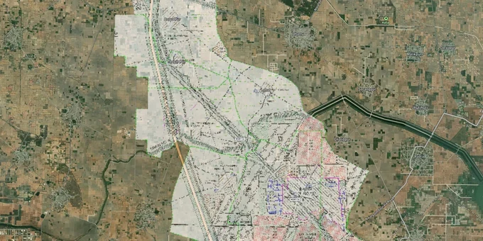
Arogya Dham Badsa Masterplan Preview
Try the Arogya Dham Badsa Masterplan on the map
Sign in once and explore the layer for a full day.
- No card details needed
- Find nearby verified lands for sale
Overview
The Arogya Dham Badsa Masterplan 2041 is the final development plan for Badsa village in Jhajjar district, Haryana, gazetted on 9 August 2019 under notification CCP(NCR)/FDP/Badsa/2019/1601 by the Department of Town and Country Planning (TCP), Haryana. The total planning area covers 1,085 hectares across six land-use zones. Residential use accounts for 386 hectares (35.58%), Public and Semi-Public for 358 hectares (32.99%), and Open Spaces for 107 hectares (9.87%). This page covers the Change of Land Use (CLU) and licensing risks specific to the Badsa masterplan zone, the corridors where zone classification aligns with real investment demand, and how to verify any plot before purchase.
Unlicensed Layouts and the CLU Trap: The Two Bad Zone Risks That Stop Sales
The Arogya Dham Badsa Masterplan 2041 designates over 32% of the planning area as Public and Semi-Public use, primarily driven by the National Cancer Institute (NCI-AIIMS) campus and its support infrastructure. This is the highest public-use allocation of any comparable Haryana development plan. Plots marketed as residential in this zone category are either misrepresented or rely on a Change of Land Use (CLU) order that buyers rarely see before paying a token.
The second risk is unlicensed colonies. In Haryana, no private residential layout can legally be sold without a TCP licence issued under the Punjab Scheduled Roads and Controlled Areas Restriction of Unregulated Development Act, 1963. Agricultural land within the Badsa masterplan controlled area cannot be subdivided and sold as residential plots without this licence, regardless of what the seller's patta or Jamabandi record shows. Plots marketed "near AIIMS" or "near Kundli-Manesar-Palwal (KMP)" expressway without a TCP licence number are operating outside the plan, not within it.
The table below sets out the six land-use categories in the Arogya Dham Badsa Masterplan 2041 and the key buyer checks each requires.
Zone Code
Land Use
Area (Hectares)
Key Buyer Check
100
Residential
386 (35.58%)
Confirm TCP licence; no unlicensed colony marketing
200
Commercial
52 (4.79%)
CLU is required before non-commercial plot use
300
Public and Semi-Public
358 (32.99%)
NCI-AIIMS zone; private residential not permitted
400
Transport and Communication
113 (10.41%)
KMP Expressway 100m green belt; 30m green belt on V-roads
500
Public Utilities
69 (6.36%)
Water, drainage, power infrastructure; not buildable
700
Open Spaces
107 (9.87%)
Parks and water bodies; construction not permitted
The KMP Expressway carries a 100m wide road reservation with 100m green belts on both sides. Any plot marketed within this buffer zone cannot be developed for residential or commercial use without a CLU order specifically addressing this green belt restriction. A TCP licence number matched to the specific khasra number is the only document that confirms a layout is clean.
AIIMS Badsa to MET City: Where the Masterplan 2041 Zone Drives Actual Investment Demand
The Badsa masterplan 2041 sits at the convergence of two major infrastructure investments: the NCI-AIIMS campus at Badsa and the Reliance MET City industrial township. Residential demand in this corridor is real, but the planning zone frame is tight. The sectors carved out under the Deen Dayal Jan Awas Yojana (DDJAY) are the only government-policy-enabled source of affordable licensed residential plots in the area, and TCP-licensed layouts within the masterplan boundary are limited.
The Haryana Chief Secretary formally directed in January 2023 that the AIIMS campus at Badsa be developed into a mini city with a full complement of commercial, educational, and institutional support. The Greenfield Corridor (announced January 2023; no construction started as of April 2026) connecting AIIMS Badsa to the IGI Airport via Dwarka Expressway is a planned infrastructure project. Both of these are growth catalysts confirmed in official communications. The distinction that matters for buyers is whether a specific plot sits inside the masterplan boundary with a TCP licence, or outside it on agricultural land being sold on proximity to these projects.
The table below shows the corridors within and adjacent to the Badsa masterplan where zone classification directly affects investment decision-making.
Corridor
Zone Profile
Growth Driver
Key Risk
Badsa Sectors (DDJAY layouts)
Residential (Code 100)
NCI-AIIMS proximity, licensed affordable housing policy
Confirm TCP licence and Haryana Real Estate Regulatory Authority (HRERA) registration before signing
NCI-AIIMS campus periphery
Public and Semi-Public (Code 300)
National Cancer Institute demand for support services
Private residential is not permitted in the core campus zone
KMP Expressway frontage
Transport and Communication (Code 400)
Expressway access to Delhi NCR, Reliance MET City
A 100m green belt on both sides prohibits construction
Badsa-Badli corridor
Residential / Transitional
SGT University proposed metro connectivity
Verify plot is within the DP 2041 boundary, not outside on patta land
MET City adjacency
Industrial / Commercial edge
Reliance Industrial Township
Industrial zone adjacency; residential CLU required
The AIIMS-adjacent residential market is the most misread. Plots offered here at agricultural rates with promises of future CLU permission carry the highest risk in the entire plan area. A future CLU is not a current right.
Was this layer helpful?
Anything wrong, outdated, or missing we want to hear it.
For Land Owners & Agents
Looking to sell your land in Delhi?
I want to sell my land in Delhi
10:32
Plz share your Land's location - We will list it on 1acre map, for Free.
10:32

For Land Buyers
Browse all verified lands & plots in Delhi NCR
Every listing goes through our Preliminary Verification Process.
More Layers in Delhi NCR
See all 30 layers
Alwar UIT Masterplan 2031: Zone Check and Land Use Guide
View Alwar Masterplan as a live map overlay – check any plot's land use zone for free on 1acre.in. Alwar Master Plan 205...

Baghpat Baraut Khekra Masterplan: Zone Check and Land Use Guide
View Bhagpat-Baraut-Khekra Masterplan as a live map overlay – check any plot's land use zone for free on 1acre.in. Baghp...
Delhi Master Plan 2041: DDA Zone Check and Land Use Guide
View Delhi Masterplan as a live map overlay – check any plot's land use zone for free on 1acre.in. Delhi masterplan land...
More Layers in Delhi NCR
Alwar UIT Masterplan 2031: Zone Check and Land Use Guide
View Alwar Masterplan as a live map overlay – check any plot's land use zone for free on 1acre.in. Alwar Master Plan 205...
Baghpat Baraut Khekra Masterplan: Zone Check and Land Use Guide
View Bhagpat-Baraut-Khekra Masterplan as a live map overlay – check any plot's land use zone for free on 1acre.in. Baghp...
Delhi Master Plan 2041: DDA Zone Check and Land Use Guide
View Delhi Masterplan as a live map overlay – check any plot's land use zone for free on 1acre.in. Delhi masterplan land...