Faridabad Masterplan 2031: Zone Check and Land Use Guide
Faridabad Masterplan Preview
Try the Faridabad Masterplan 2031 on the map
Sign in once and explore the layer for a full day.
- No card details needed
- Find nearby verified lands for sale
Overview
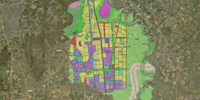
Faridabad Masterplan 2031, formally the Final Development Plan notified by DTCP Haryana in January 2018, governs 638 sq km under the Faridabad Metropolitan Development Authority (FMDA). It proposes 67 new sectors across 34,368 hectares, targeting a population of 38.86 lakh. The entire district is a Faridabad controlled area plot zone - meaning any purchase without a CLU order or DTP NOC is legally void from day one. This page covers the zone rules that actually matter, the fraud patterns the DTP has documented, and the specific corridors where the Faridabad Masterplan 2031 land buying case is strongest in 2025.
Why Plots in Faridabad Get Demolished After Purchase - The CLU and NOC Rules No One Explains Clearly
Most buyers who lose money in Faridabad land deals did not get cheated on price. They got cheated on paperwork. The whole district is a controlled area under DTCP Haryana. That means carving out a plot from agricultural land without a Change of Land Use (CLU) order from FMDA, or selling in an unlicensed colony without a DTP NOC, is a criminal act - not just a civil one.
The DTP has identified 554 unauthorised colonies across Faridabad district. Even that number is likely low. In November 2024, the DTP enforcement team demolished 11 structures near Baselwa Colony in Greater Faridabad, sectors 86-87, for a second time at the same location - the illegal construction had simply reappeared after the first demolition eight months earlier. That is what the risk looks like on the ground.
The most common method of sale in these unauthorised colonies is a General Power of Attorney (GPA), not a registered sale deed. Sub-divisional revenue officials have standing orders not to register plots without a DTP NOC. In practice, those registrations still happen. A senior lawyer who has tracked Faridabad land cases told The Tribune that corruption allows non-compliant registrations to continue despite the directive.
The table below shows the four documents to demand before any Faridabad land transaction:
Document
What It Confirms
Where to Verify
CLU Order
Land use changed from agricultural to residential/commercial
fmda.haryana.gov.in
DTP NOC
Plot subdivision cleared in controlled area
DTP Faridabad / FMDA OneMap
Colony Licence
Developer authorised to sell plots in this layout
tcpharyana.gov.in
Registered Sale Deed
Title transfers by deed, not GPA
Sub-registrar office
A plot sold via GPA in a Faridabad controlled area has no title protection. If the DTP demolishes the structure, you have no legal recourse through the sale document. Demand a registered sale deed and verify the colony licence on tcpharyana.gov.in before paying any token amount.
Neharpar, Sectors 64-110, and the Ballabhgarh Belt: Three Very Different Investment Bets
The Faridabad Masterplan 2031 land buying opportunity is not spread evenly across the city. Three corridors are active right now, and each carries a distinct risk-return profile.
The eastern corridor, from Sector 64 through Ballabhgarh toward Jewar, is the plan's highest-conviction growth zone. In March 2026, the Union Cabinet approved a revised outlay of Rs 3,630.77 crore for the 31.42 km Greenfield Expressway connecting Faridabad to Jewar International Airport, including an 11 km elevated stretch near Sector 65. The expressway corridor runs directly through the high-density development zone earmarked under Masterplan 2031. Sectors 64, 65, 98, and 110 are already seeing measurably stronger demand.
The second corridor is Greater Faridabad, or Neharpar: Sectors 66 to 89 between the Agra Canal and the Yamuna. This is an established residential market with metro connectivity. Most land available here was planned under the 2011 development plan, not the 2031 extension. Buyers looking for raw land appreciation linked to new sector development will not find it in Neharpar at today's prices.
The third corridor is the southern belt near Chandawali, Sotai, and Bahbalpur villages. These villages lie inside the Masterplan 2031 expansion area east of the Agra Canal, and the land near the Yamuna has been declared a controlled zone to prevent unplanned growth pending sector development. Infrastructure here is years away.
Corridor
Key Sectors/Areas
Primary Driver
Honest Risk
Eastern (Greenfield Expressway belt)
64, 65, 98, 110
Jewar Airport link; Delhi-Mumbai Expressway
Expressway at ~35% completion; buy only in licensed sectors
Greater Faridabad (Neharpar)
66-89
Metro, NH-44 connectivity
Premium pricing; mostly 2011-plan land
Southern belt (Chandawali, Sotai)
New Masterplan 2031 villages
Future sector development
No infrastructure yet; highest regulatory risk
The Greenfield Expressway's original June 2025 deadline has already slipped by 12-15 months due to construction delays. Budget has risen by roughly 48%. That does not change the long-term case for the corridor, but anyone pricing in a near-term completion is misjudging the timeline.
Was this layer helpful?
Anything wrong, outdated, or missing we want to hear it.
For Land Owners & Agents
Looking to sell your land in Delhi?
I want to sell my land in Delhi
10:32
Plz share your Land's location - We will list it on 1acre map, for Free.
10:32

For Land Buyers
Browse all verified lands & plots in Delhi NCR
Every listing goes through our Preliminary Verification Process.
More Layers in Delhi NCR
See all 30 layers
Alwar UIT Masterplan 2031: Zone Check and Land Use Guide
View Alwar Masterplan as a live map overlay – check any plot's land use zone for free on 1acre.in. Alwar Master Plan 205...
Arogya Dham Badsa Masterplan: Zone Check and Land Use Guide
View Arogya Dham Badsa Masterplan as a live map overlay – check any plot's land use zone for free on 1acre.in. Arogya Dh...

Baghpat Baraut Khekra Masterplan: Zone Check and Land Use Guide
View Bhagpat-Baraut-Khekra Masterplan as a live map overlay – check any plot's land use zone for free on 1acre.in. Baghp...
More Layers in Delhi NCR
Alwar UIT Masterplan 2031: Zone Check and Land Use Guide
View Alwar Masterplan as a live map overlay – check any plot's land use zone for free on 1acre.in. Alwar Master Plan 205...
Arogya Dham Badsa Masterplan: Zone Check and Land Use Guide
View Arogya Dham Badsa Masterplan as a live map overlay – check any plot's land use zone for free on 1acre.in. Arogya Dh...
Baghpat Baraut Khekra Masterplan: Zone Check and Land Use Guide
View Bhagpat-Baraut-Khekra Masterplan as a live map overlay – check any plot's land use zone for free on 1acre.in. Baghp...