Loni GDA Masterplan: Zone Check and Land Use Guide
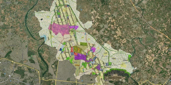
Loni Masterplan Preview
Try the Loni GDA Masterplan on the map
Sign in once and explore the layer for a full day.
- No card details needed
- Find nearby verified lands for sale
Overview
Every plot in Loni gets its development rights from the GIS-based Loni Master Plan 2031 (Draft), prepared by the Ghaziabad Development Authority under the Urban Planning and Development Act, 1973. The plan covers 7,980 hectares across Loni tehsil in Ghaziabad district, dividing the area into three planning zones. The unified Ghaziabad Master Plan 2031 received UP government approval in August 2025, with Loni identified as one of three centres of development alongside Ghaziabad city and Modinagar. Two specific risks define land buying in this corridor: the GDA's published unauthorized colonies list and the Hindon Airbase proximity zone.
Bhopura, Loni Rural, and the Hindon Airbase Corridor: Where Zone and Infrastructure Intersect
Loni's geography places it at a unique intersection: it borders North East Delhi to the south and sits within the proximity zone of Hindon Airbase (Air Force Station Hindon) to the west. Hindon Airbase is a major Indian Air Force base whose 10.25 sq km area sits adjacent to the Loni-Bhopura-Ghaziabad urban corridor. Construction near the airbase requires NOC from the Airport Authority of India and IAF for height restrictions, a fact that does not appear in any broker's pitch but is documented in building permission requirements across the NCR.
The Master Plan 2031 divides Loni into three planning zones. The plan also notes connectivity to Delhi via NH-44 (Delhi-Saharanpur road) and existing roads toward Muradnagar and Ghaziabad. GDA proposed a 20 km Northern Peripheral Road connecting Hapur via Meerut to Hindon, Bhopura, and Loni, with an estimated cost of Rs 260 crore. A September 2024 DMRC proposal for the Pink Line extension from Gokulpuri to Arthala includes a Bhopura station on the planned route, which passes through the Loni corridor. Neither project is operational yet.
The table below maps the key corridors and localities in the Loni Master Plan zone against their growth drivers and risks.
Corridor / Locality
Zone Context
Growth Driver
Known Risk
Bhopura
Residential / Mixed
NH-44 access, proposed Pink Line Bhopura station
Hindon Airbase proximity; height NOC required
Loni Rural
Gramin Abadi / Agricultural fringe
Delhi border proximity
Non-conforming use zones; UPSIDC acquisition entries
Mandola, Agraula
Residential / Agricultural
GDA planned zone expansion
Agricultural land sold at residential rates without CLU
Tila Shahbazpur, Nistauli
Agricultural / Residential fringe
Loni tehsil village belt
No GDA-approved layout in many pockets
Bhopura to Hindon corridor
Residential / Mixed
Proposed Pink Line metro extension
Airbase height restrictions; building NOC mandatory
The Bhopura corridor is the most misunderstood. Its proximity to both Delhi and the proposed Bhopura Pink Line metro station makes it attractive, but any plot within the flight path or airbase height funnel requires an explicit NOC before construction. Do not proceed on any plot in this corridor without confirming the height restriction status with the GDA office.
Was this layer helpful?
Anything wrong, outdated, or missing we want to hear it.
For Land Owners & Agents
Looking to sell your land in Delhi?
I want to sell my land in Delhi
10:32
Plz share your Land's location - We will list it on 1acre map, for Free.
10:32

For Land Buyers
Browse all verified lands & plots in Delhi NCR
Every listing goes through our Preliminary Verification Process.
More Layers in Delhi NCR
See all 30 layers
Alwar UIT Masterplan 2031: Zone Check and Land Use Guide
View Alwar Masterplan as a live map overlay – check any plot's land use zone for free on 1acre.in. Alwar Master Plan 205...
Arogya Dham Badsa Masterplan: Zone Check and Land Use Guide
View Arogya Dham Badsa Masterplan as a live map overlay – check any plot's land use zone for free on 1acre.in. Arogya Dh...

Baghpat Baraut Khekra Masterplan: Zone Check and Land Use Guide
View Bhagpat-Baraut-Khekra Masterplan as a live map overlay – check any plot's land use zone for free on 1acre.in. Baghp...
More Layers in Delhi NCR
Alwar UIT Masterplan 2031: Zone Check and Land Use Guide
View Alwar Masterplan as a live map overlay – check any plot's land use zone for free on 1acre.in. Alwar Master Plan 205...
Arogya Dham Badsa Masterplan: Zone Check and Land Use Guide
View Arogya Dham Badsa Masterplan as a live map overlay – check any plot's land use zone for free on 1acre.in. Arogya Dh...
Baghpat Baraut Khekra Masterplan: Zone Check and Land Use Guide
View Bhagpat-Baraut-Khekra Masterplan as a live map overlay – check any plot's land use zone for free on 1acre.in. Baghp...