Ayodhya Air Funnel Zones
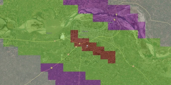
Ayodhya Air Funnel Zones Preview
Try the Ayodhya Air Funnel Zones on the map
Sign in once and explore the layer for a full day.
- No card details needed
- Find nearby verified lands for sale
Overview
Ayodhya airport height restriction zone rules apply to every plot within 20 km of Maharishi Valmiki International Airport (IATA: AYJ), operated by AAI on NH-27 near Naka, Faizabad. The airport opened in December 2023 and is undergoing a Rs 1,625 crore expansion to handle 6 million passengers annually. Any structure in this radius requires a height clearance NOC from AAI before construction begins.
Ayodhya Airport Funnel Zone Rules That Can Invalidate Your Building Plan
Most buyers near Naka and Faizabad assume their plot is fine because a local broker gave verbal clearance. It is not fine until AAI says so in writing. Two facts matter here: where your plot sits relative to the runway and the total height of your proposed structure measured from mean sea level (AMSL), not from the ground.
Height Restrictions Within the Ayodhya Funnel Zone
The Ministry of Civil Aviation (Height Restrictions for Safeguarding of Aircraft Operations) Rules, 2015 (GSR 751E) govern every structure within 20 km of the Aerodrome Reference Point (ARP) of Maharishi Valmiki International Airport. The airport funnel zone, the most restrictive surface, runs along the runway approach and departure paths. Inside it, permitted building height equals 2% of the distance from the runway edge. So a plot 1,000 meters from the runway end has a ceiling of just 20 meters AGL. The table below shows how height limits shift across the main OLS zones.
Zone
Distance from Runway / ARP
Max Permitted Height
NOC Required?
Runway Strip (No-build)
0-500 m
No construction
Yes, mandatory
Inner Horizontal Surface
Up to 4 km from ARP
45 m AGL
Yes
Conical Surface
4-8 km approx.
Increases 1 m per 20 m distance
Yes
Outer Horizontal Surface
Up to 15 km
Up to 300 m AMSL
Yes
Peripheral Zone
15-20 km
No hard cap, but monitored
Yes
Airport Funnel (Approach path)
Aligned with runway ends
2% of distance from runway edge
Yes
AAI measures height in AMSL, not floors. A plot at higher ground elevation in Naka can breach the Permissible Top Elevation (PTE) even with a three-story building. If your plot is in a red grid on the CCZM (Color Coded Zoning Map), local bodies cannot approve the building plan at all. You must file through NOCAS directly. Roughly 40% of height clearance NOC applications nationally are rejected by AAI. Get the NOC before the registry, not after.
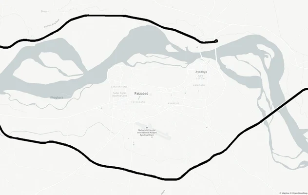
Naka, Usru and Faizabad Bypass: Which Corridors Face the Tightest Limits
The airport sits at Naka and Usru villages on NH-27, with Faizabad Junction just 6.8 km to the north-west. Plots in these localities sit closest to the ARP and therefore carry the strictest height ceilings. Darshan Nagar sits further east toward Ayodhya City and has attracted plotted development; its greater distance from the runway gives slightly more headroom, but it still falls within the 20 km NOC radius.
The table below maps the corridors buyers are most actively targeting and the key risk factor in each.
Corridor / Locality
Distance to ARP (approx.)
Primary Height Risk
ADA Master Plan Zone
Naka (airport village)
0-2 km
Funnel zone: extreme restriction
Transport / Airport use
Usru Village
Adjacent to airport
Inner horizontal surface limit
Airport buffer
Faizabad Bypass Road
5-8 km
Conical surface rules apply
Mixed-use / Commercial
Darshan Nagar
8-12 km
Outer horizontal surface
Residential
NH-27 Corridor toward Ayodhya
10-15 km
Peripheral zone, monitored
Residential / Commercial
The most misunderstood corridor is the Faizabad Bypass Road. Brokers pitch it as "airport-adjacent" for connectivity premium but rarely mention that plots here sit inside the conical surface. A four-floor apartment that looks compliant with local bylaws can still breach AAI's AMSL ceiling. Always request the Permissible Top Elevation from NOCAS for the exact survey coordinates before paying the token amount.
Was this layer helpful?
Anything wrong, outdated, or missing we want to hear it.
For Land Owners & Agents
Looking to sell your land in Uttar Pradesh?
I want to sell my land in Uttar Pradesh
10:32
Plz share your Land's location - We will list it on 1acre map, for Free.
10:32

For Land Buyers
Browse all verified lands & plots in Uttar Pradesh
Every listing goes through our Preliminary Verification Process.
More Layers in Uttar Pradesh
See all 32 layers
Ayodhya Masterplan
View Ayodhya Masterplan as a live map overlay – check any plot's land use zone for free on 1acre.in. Ayodhya masterplan ...
Ayodhya Ring Road
View Ayodhya Ring Road alignment as a live map overlay – check land acquisition risk and plot proximity free on 1acre.in...
Lucknow Masterplan
View Lucknow Masterplan as a live map overlay – check any plot's land use zone for free on 1acre.in. Lucknow masterplan ...
More Layers in Uttar Pradesh
Ayodhya Masterplan
View Ayodhya Masterplan as a live map overlay – check any plot's land use zone for free on 1acre.in. Ayodhya masterplan ...
Ayodhya Ring Road
View Ayodhya Ring Road alignment as a live map overlay – check land acquisition risk and plot proximity free on 1acre.in...
Lucknow Masterplan
View Lucknow Masterplan as a live map overlay – check any plot's land use zone for free on 1acre.in. Lucknow masterplan ...