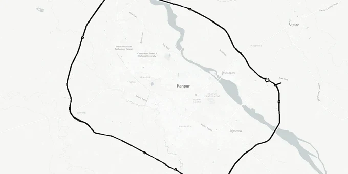
Kanpur Ring Road
Kanpur Ring Road Preview
Try the Kanpur Ring Road on the map
Sign in once and explore the layer for a full day.
- No card details needed
- Find nearby verified lands for sale
Overview
The Kanpur Ring Road land corridor, officially called Udyog Path, is a 93.21-kilometre six-lane greenfield access-controlled highway encircling Kanpur city. Built by NHAI (National Highways Authority of India) at an estimated cost of Rs 5,182 crore, it passes through three districts: Kanpur Nagar (62 km), Unnao (27 km), and Kanpur Dehat (4 km). The alignment runs from Mandhana on the Kanpur Aligarh Highway through Sachendi, Ramaipur, Chakeri Airport, Trans Ganga City, and back to Mandhana via the Ganga River crossing. Construction is active on three of five packages, with completion targeted for January 2027.
Packages 2A and 2B are being executed on EPC (Engineering, Procurement and Construction) mode.
The project's foundation stone was laid by Nitin Gadkari in January 2024.
What Buyers Near the Kanpur Outer Ring Road Must Verify Before Transacting
NHAI has acquired 700 hectares of land for this ring road across 271 villages in Kanpur Nagar, Kanpur Dehat, and Unnao districts. Phase 1 alone, the 22.5-km Mandhana to Sachendi stretch, pulled in land from 79 villages. That scale of acquisition means one specific risk is active across the entire perimeter: farmers and landowners whose parcels fall within the notified boundary have been entering the informal sale market with adjacent plots, sometimes without disclosing that their own original land is under NHAI notification.
The first step before any transaction near this corridor is to cross-check the khasra against the NHAI acquisition notifications for the specific package zone. The Kanpur district land records portal lists notified villages for each phase. If the khasra is in a notified village and the broker cannot show a revenue record confirming the plot sits outside the ROW, do not proceed.
Three additional risk categories are specific to this corridor and not addressed by generic ring road guidance.
The table below maps each risk type to the affected package zone.
Risk Category
Package Zone
Specific Issue
Verification Step
Notified village boundary overlap
All packages, 271 villages total
Adjacent plots sold without disclosure of NHAI notification
Check khasra in Kanpur district land records against phase-wise notification
Ganga River bridge approach
Package 2A (Mandhana-Bithoor belt)
3.2 km Ganga bridge ROW; both banks have development buffer
Confirm plot boundary is outside bridge approach ROW
Package 2A re-tendering gap
Mandhana to Trans Ganga City
Package 2A re-tendering on EPC mode was finalised in mid-2025; 22 bidders had technically qualified by October 2024. Confirm contractor appointment and construction commencement status before purchasing in this belt.
Alignment in this stretch is confirmed but construction delayed; do not buy on inflated pre-completion pricing
Defence Corridor adjacency
Package 3 and 4 (Ramaipur to Sachendi)
UPDIC (UP Defence Industrial Corridor) Kanpur node proximity may create zoning restrictions
Check UPDIC node boundary before industrial or commercial land purchase
The Package 2A gap is the sharpest near-term risk for buyers. The 8.765-km stretch from Mandhana to Trans Ganga City had its tender re-tendered on EPC mode, with finalisation reported in mid-2025 and 22 qualified bidders as of October 2024. Brokers are actively selling plots in this belt as if the road is already under active construction. It is not yet, in this specific package. Package 1 (Sachendi to Mandhana) and Package 4 (Jarkala to Pakri via Defence Corridor) have contractors and are building. Package 2A does not. Price your entry accordingly.
Where Real Demand Is Building Along the Kanpur Outer Ring Road
The Kanpur Ring Road will offload an estimated 4.5 lakh vehicles daily from city roads once operational. That volume of freight and passenger traffic creates real demand nodes, but they are not evenly distributed around the 93-km perimeter.
The strongest commercial demand will concentrate at the three major interchange points where the ring road crosses existing national highways: NH-19 at Sachendi, NH-27 at the Trans Ganga City junction in the north, and the Hamirpur Road near Ramaipur where the Defence Corridor connection sits. Each of these points has a documented development plan attached: Sachendi connects with the Awadh Expressway near Amarsus village; Trans Ganga City already has proposed IT cities, integrated townships, and a Wellness City along its perimeter; Ramaipur feeds the UPDIC Kanpur node.
The table below gives the investment profile for each major corridor pocket.
Corridor Pocket
Highway Connection
Primary Demand Driver
Hold Period
Key Risk
Sachendi interchange
NH-19, Awadh Expressway junction
Logistics, freight; Awadh Expressway trijunction
3-5 years
79 village acquisition notification; verify khasra
Trans Ganga City belt
NH-27, Lucknow Highway
IT city, integrated township, residential
3-6 years
Package 2A retendering delay; pre-completion pricing inflated
Ramaipur / Defence Corridor
Hamirpur Road, UPDIC node
Industrial, defence supply chain
4-7 years
UPDIC zone restrictions apply to adjacent land
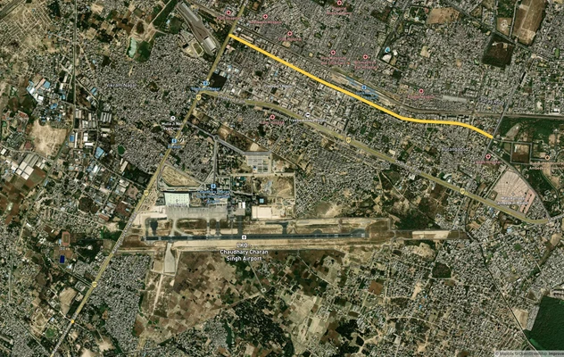
Chakeri Airport approach
Airport link road, Prayagraj Highway
Commercial, warehousing, hospitality
4-6 years
Airport link road is proposed, not yet constructed
Mandhana, Bithoor belt
Kanpur Aligarh Highway
Residential; Ganga bridge corridor
3-5 years
Bridge ROW buffer on both banks of Ganga
Corridor Pocket
Highway Connection
Primary Demand Driver
Hold Period
Key Risk
Sachendi interchange
NH-19, Awadh Expressway junction
Logistics, freight; Awadh Expressway trijunction
3-5 years
79 village acquisition notification; verify khasra
Trans Ganga City belt
NH-27, Lucknow Highway
IT city, integrated township, residential
3-6 years
Package 2A retendering delay; pre-completion pricing inflated
Ramaipur / Defence Corridor
Hamirpur Road, UPDIC node
Industrial, defence supply chain
4-7 years
UPDIC zone restrictions apply to adjacent land
Chakeri Airport approach
Airport link road, Prayagraj Highway
Commercial, warehousing, hospitality
4-6 years
Airport link road is proposed, not yet constructed
Mandhana, Bithoor belt
Kanpur Aligarh Highway
Residential; Ganga bridge corridor
3-5 years
Bridge ROW buffer on both banks of Ganga
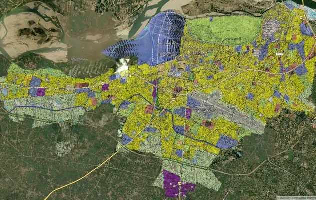
Trans Ganga City is the most misread pocket on this ring road. Developers and brokers have been marketing plots in the Trans Ganga City area on the basis of planned IT cities and educational hubs. Those proposals exist in the UP government's development plan for the Kanpur Metropolitan Area. But none of them have official layout sanctions or construction timelines as of mid-2025. Agricultural land sold as "Trans Ganga City adjacent" requires an independent check: confirm the specific survey number is within a sanctioned layout, not raw agricultural land branded with a township name.
Was this layer helpful?
Anything wrong, outdated, or missing we want to hear it.
For Land Owners & Agents
Looking to sell your land in Uttar Pradesh?
I want to sell my land in Uttar Pradesh
10:32
Plz share your Land's location - We will list it on 1acre map, for Free.
10:32

For Land Buyers
Browse all verified lands & plots in Uttar Pradesh
Every listing goes through our Preliminary Verification Process.
More Layers in Uttar Pradesh
See all 32 layers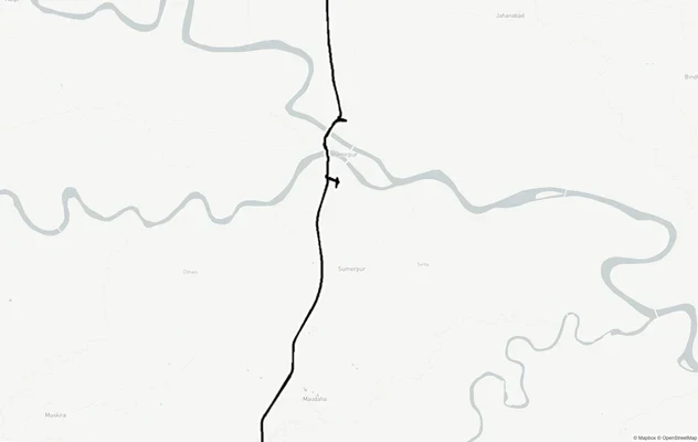
Kanpur - Kabrai Highway
View Kanpur - Kabrai Highway alignment as a live map overlay – check land acquisition risk and plot proximity free on 1a...
Kanpur Road - Within Lucknow
View the Kanpur Road - Within Lucknow corridor on a live map overlay – check zoning, approvals and acquisition risk free...
Ayodhya Masterplan
View Ayodhya Masterplan as a live map overlay – check any plot's land use zone for free on 1acre.in. Ayodhya masterplan ...
More Layers in Uttar Pradesh
Kanpur - Kabrai Highway
View Kanpur - Kabrai Highway alignment as a live map overlay – check land acquisition risk and plot proximity free on 1a...
Kanpur Road - Within Lucknow
View the Kanpur Road - Within Lucknow corridor on a live map overlay – check zoning, approvals and acquisition risk free...
Ayodhya Masterplan
View Ayodhya Masterplan as a live map overlay – check any plot's land use zone for free on 1acre.in. Ayodhya masterplan ...