Lucknow Air Funnel Zones
Lucknow Air Funnel Zones Preview
Try the Lucknow Air Funnel Zones on the map
Sign in once and explore the layer for a full day.
- No card details needed
- Find nearby verified lands for sale
Overview
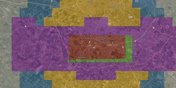
The Lucknow airport height restriction zone covers all land within 20 km of the Aerodrome Reference Point (ARP) of Chaudhary Charan Singh International Airport (CCSIA) in Amausi. The governing document is AAI's Color-Coded Zoning Map (CCZM) for Lucknow, issued under GSR 751(E) dated 30 September 2015. Lucknow is among the first cities in India for which this map was prepared and handed to local bodies, including LDA and LMC. This page explains how the CCZM operates, what the 35% height-increase plateau means for buyers at distance from the runway, which corridors carry the highest demolition risk, and what the Aerocity land push near Rahimabad means for investors.
LDA Notices, Demolition Risk, and the NOC Gap Builders Exploit Near CCSIA
The single biggest risk in the Lucknow Airport height restriction zone is not the rule itself; it is the gap between LDA plan approval and a valid AAI NOC. Under GSR 751(E) Rule 5, every structure within 20 km NOCAS or requires either a direct NOC from AAI through NOCAS, or confirmation that the proposed height falls below the CCZM Permissible Top Elevation (PTE) for that grid. LDA or LMC plan approval alone does not satisfy this requirement for plots in red-coded grids or on approach and take-off paths. Builders have exploited this gap systematically.
In August 2024, LDA issued demolition notices to 50 houses built directly next to the CCSIA boundary. An LDA official confirmed a builder had posed as a contractor, acquired land from farmers in Rahimabad and Mohammadpur Bhakti Kheda without obtaining a mandatory NOC from airport administration, and pocketed the proceeds. In July 2025, LDA issued notices to 15 high-rise buildings near the airport whose upper floors violate height limits. LDA, the district administration, and airport management conducted a joint survey before issuing these notices. Upper floors of the flagged structures are to be demolished.
The enforcement split between LDA, LMC, and airport management is structural. None of the three has sole demolition authority; coordinated action requires a joint survey, which takes time. Buildings can stand in violation for years before enforcement catches up. Buyers of upper-floor flats in any project within the inner zone who cannot produce the builder's AAI NOC certificate are the ones who bear the consequence.
The table below shows the regulatory levels that apply at different distances from CCSIA's ARP under GSR 751(E).
Distance from ARP
Maximum Permitted Structure
NOC Required?
Approved By
0–500 m (runway strip)
No construction
Prohibited
N/A
500 m–4 km (inner horizontal surface)
45 m AGL maximum
Yes, from AAI
AAI only
4–15 km (outer horizontal surface)
1 m per 20 m of distance; up to 300 m
Only if above CCZM PTE
LDA/LMC if below PTE; AAI if above
15–20 km (peripheral zone)
No height cap; NOC still required
Yes
AAI via NOCAS
Ask the builder for the NOCAS application number and the AAI NOC certificate before you pay a booking amount. If they cannot produce both, the upper floors of that building are legally at risk.
Amausi, Rahimabad, and the Aerocity Corridor: Where Height Caps Shape Investment Risk
Lucknow's CCZM has a documented characteristic that sets it apart from several other Indian airports: as the distance from CCSIA increases from 6 km to 15 km, the building height threshold rises by only approximately 35%. In cities like Amritsar and Chennai, the equivalent increase over the same distance is 100%. This means Lucknow buyers get almost no relief from height constraints as they move outward through densely developed zones like Alambagh, Sarojini Nagar, and Amausi proper.
Amausi and Sarojini Nagarsit within 4 km of the runway via NH-27 and lie in the tightest CCZM bands. The inner horizontal surface rule caps structures at 45 m AGL here. Any multi-story project in this pocket, regardless of what LDA permits, requires direct AAI NOC. The Kridha Aerocity project at Sarojini Nagar advertises proximity to the CCSIA metro station; buyers there must independently verify AAI NOC status for every floor above ground level.
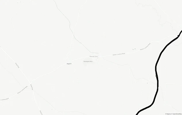
Rahimabadis the corridor to watch for a different reason. It sits immediately east of the airport boundary and is precisely the area where LDA issued the August 2024 demolition notices for 50 unauthorized houses. Average transaction rates here are approximately ₹2,499 per sq ft. The Lucknow Aerocity project, announced in the UP Budget 2024 and pegged at 1,500 acres, is planned for Rahimabad and Gahru villages. On 25 October 2024 the Supreme Court dismissed farmers' pleas against airport expansion, clearing LDA to proceed. That ruling accelerates land acquisition in this corridor; it does not resolve the height restriction that will apply to any commercial or residential development on the Aerocity land.
Gomti Nagar,at approximately 12–14 km from CCSIA, begins to enter the outer horizontal surface where CCZM headroom increases, though Lucknow's flat 35% gradient means usable height remains constrained relative to buyer expectations.
The table below maps these corridors to their risk profile.
Locality / Corridor
Distance from ARP
Demolition Risk
Key Constraint
Amausi / Sarojini Nagar
~2–4 km
Very High
Inner horizontal surface; 45 m AGL cap; direct AAI NOC mandatory
Rahimabad / Mohammadpur Bhakti Kheda
~1–3 km
Very High
Active demolition notices; land acquisition ongoing for Aerocity
Alambagh
~6–8 km
Moderate-High
Flat CCZM gradient, height ceiling barely rises, verify grid
Gomti Nagar
~12–14 km
Moderate
Outer surface zone: more headroom, but 15–20 km peripheral NOC still applies
Rahimabad is the most misread corridor in Lucknow's airport zone. Buyers see low land prices and Aerocity headlines and assume construction rights are expanding. They are contracting.
Was this layer helpful?
Anything wrong, outdated, or missing we want to hear it.
For Land Owners & Agents
Looking to sell your land in Uttar Pradesh?
I want to sell my land in Uttar Pradesh
10:32
Plz share your Land's location - We will list it on 1acre map, for Free.
10:32

For Land Buyers
Browse all verified lands & plots in Uttar Pradesh
Every listing goes through our Preliminary Verification Process.
More Layers in Uttar Pradesh
See all 32 layers
Lucknow Masterplan
View Lucknow Masterplan as a live map overlay – check any plot's land use zone for free on 1acre.in. Lucknow masterplan ...
Lucknow Outer Ring Road
View the Lucknow Outer Ring Road corridor on a live map overlay – check zoning, approvals and acquisition risk free on 1...
Lucknow - Kanpur Expressway
View Lucknow - Kanpur Expressway alignment as a live map overlay – check land acquisition risk and plot proximity free o...
More Layers in Uttar Pradesh
Lucknow Masterplan
View Lucknow Masterplan as a live map overlay – check any plot's land use zone for free on 1acre.in. Lucknow masterplan ...
Lucknow Outer Ring Road
View the Lucknow Outer Ring Road corridor on a live map overlay – check zoning, approvals and acquisition risk free on 1...
Lucknow - Kanpur Expressway
View Lucknow - Kanpur Expressway alignment as a live map overlay – check land acquisition risk and plot proximity free o...