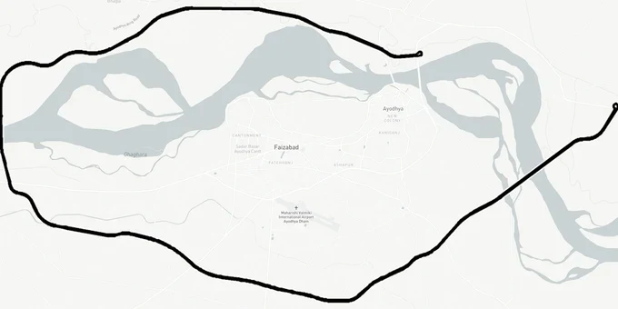
Ayodhya Ring Road
Ayodhya Ring Road Preview
Try the Ayodhya Ring Road on the map
Sign in once and explore the layer for a full day.
- No card details needed
- Find nearby verified lands for sale
Overview
The Ayodhya Ring Road land corridor spans 67.57 kilometres, divided into two packages under NHAI (National Highways Authority of India)'s NHDP Phase-VII (National Highways Development Programme Phase 7) on Hybrid Annuity Mode: the 35.40 km Northern Ayodhya Bypass and the 32.172 km Southern Ayodhya Bypass. Budgeted at Rs 3,935 crore, the project connects NH-27, NH-330A, NH-330, and NH-135A across Ayodhya, Gonda, and Basti districts. Land acquisition covers 392 hectares at a cost of Rs 690 crore. Construction officially commenced on July 9, 2025, with a 2.5-year deadline.
What Buyers Near the Ayodhya Bypass Must Verify Before Any Transaction
The Ram Mandir consecration triggered one of the fastest land price spikes any Indian city has seen in recent memory. Prime land near the temple corridor has reportedly seen 5x to 15x appreciation since 2020 by some market accounts. That velocity has also created the conditions for serious fraud, and the Ayodhya bypass corridor is the epicentre.
The most documented risk is ecologically sensitive land being sold as development plots. A Scroll.in investigation found that land in Majha Jamthara, the area between Faizabad, Ayodhya and the Saryu river, was identified by a National Green Tribunal committee as state government land. Despite this, it was transacted privately at highly inflated prices. Buyers who purchased in this zone did not hold valid title. The Saryu floodplain boundary is not marked on standard broker maps. If your plot sits near the river, the Majha Jamthara area or any zone that was previously a riverbed, get an NGT and state revenue department verification before proceeding.
The table below identifies the three categories of high-risk land on this corridor.
Risk Type
Location
Specific Issue
Verification Needed
NGT-flagged ecological land
Majha Jamthara, Faizabad-Saryu belt
Former riverbed; NGT found it state government land
Revenue department + NGT case records
NHAI acquisition overlap
392-hectare acquisition zone across Ayodhya, Gonda, Basti
Farmers re-transacting already compensated parcels
Check khasra against NHAI Package 1 and 2 acquisition schedule
ADA regulation gap
343 new villages added to ADA jurisdiction in 2025
Land in newly incorporated Basti/Gonda villages has no approved layouts yet
Confirm ADA's Phase 2 planning boundary and zone classification
Saryu bridge approach zones
Northern bypass near two Saryu bridge crossings
Bridge approach zones have development restrictions
Confirm ROW buffer on both sides of each bridge crossing
The ADA (Ayodhya Development Authority) expanded its planning area to 873 sq km in 2025, incorporating 343 villages from Basti and Gonda. Most of those villages have no sanctioned layouts under the Ayodhya Master Plan 2031. Brokers are selling agricultural parcels in these newly incorporated zones as "ADA area" plots. That description is accurate but meaningless for development until ADA notifies a layout. Buying agricultural land in a newly incorporated village on the expectation of residential conversion is a speculative bet, not a titled development site.
Where Real Demand Is Building Along the Northern and Southern Bypass
The bypass creates four distinct land markets and they are not equivalent. Understanding which one you are buying into is more important than the ring road proximity itself.
The NH-27 interchange zones at both ends of the ring road, near the Lucknow approach to the north and the Gorakhpur approach to the east, are where logistics and commercial demand will concentrate first. This is consistent with how every comparable bypass has played out: freight volumes (projected to reach 216,928 vehicles by 2033 versus 89,023 in 2023) drive warehousing demand before residential.
The Gonda Road and NH-330 corridor on the western and northern arc of the ring road is where hotel and hospitality land is most actively trading. Brands including Taj, Grand Hyatt, Radisson, and Park Plaza have been flagged for planned projects within 5 km of the Ram Temple. That commercial concentration makes the Gonda Road belt a genuinely demand-backed corridor, unlike speculative agricultural parcels further out.
The table below identifies the four land market types along the bypass.
Corridor
Highway Connection
Realistic Demand Driver
Hold Period
Key Risk
Northern bypass, NH-27 approach (Lucknow side)
NH-27
Logistics, freight village, warehousing
3-5 years
Verify outside 392-hectare NHAI acquisition zone
Gonda Road / NH-330 belt
NH-330
Hospitality, pilgrimage commercial
2-4 years
Confirm ADA-sanctioned layout, not raw agricultural
Bharatkund / NH-330A
NH-330A
Heritage tourism, residential
4-6 years
Flood zone verification near Saryu proximity
Basti / Gonda village belt (new ADA addition)
Various
Peripheral township development
7-10 years
No approved layout yet; ADA Phase 2 still planning
Bharatkund on NH-330A is the most misread corridor on this bypass. Brokers cite its historical significance and proximity to the temple. The land use reality is that Bharatkund sits within the ADA's planning area but requires ADA-sanctioned conversion from agricultural to residential before any development is legally permissible. Proximity to the Ram Temple is not a substitute for a sanctioned layout plan. Confirm ADA zoning before any transaction in this belt.
Was this layer helpful?
Anything wrong, outdated, or missing we want to hear it.
For Land Owners & Agents
Looking to sell your land in Uttar Pradesh?
I want to sell my land in Uttar Pradesh
10:32
Plz share your Land's location - We will list it on 1acre map, for Free.
10:32

For Land Buyers
Browse all verified lands & plots in Uttar Pradesh
Every listing goes through our Preliminary Verification Process.
More Layers in Uttar Pradesh
See all 32 layers
Ayodhya Masterplan
View Ayodhya Masterplan as a live map overlay – check any plot's land use zone for free on 1acre.in. Ayodhya masterplan ...
Ayodhya Air Funnel Zones
View Ayodhya Air Funnel Zones on a live map – check height clearance restrictions on any plot for free on 1acre.in. Ayod...
Lucknow Masterplan
View Lucknow Masterplan as a live map overlay – check any plot's land use zone for free on 1acre.in. Lucknow masterplan ...
More Layers in Uttar Pradesh
Ayodhya Masterplan
View Ayodhya Masterplan as a live map overlay – check any plot's land use zone for free on 1acre.in. Ayodhya masterplan ...
Ayodhya Air Funnel Zones
View Ayodhya Air Funnel Zones on a live map – check height clearance restrictions on any plot for free on 1acre.in. Ayod...
Lucknow Masterplan
View Lucknow Masterplan as a live map overlay – check any plot's land use zone for free on 1acre.in. Lucknow masterplan ...