Prayagraj Ring Road
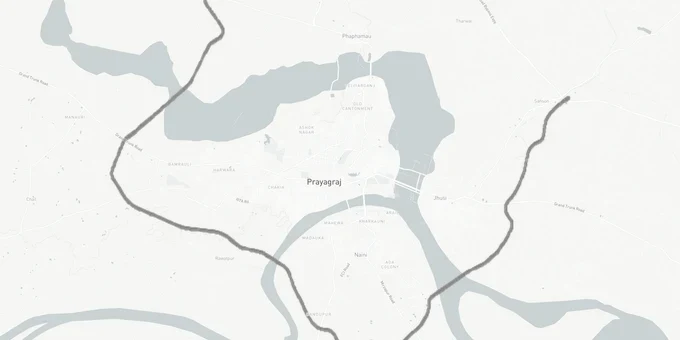
Prayagraj Ring Road Preview
Try the Prayagraj Ring Road on the map
Sign in once and explore the layer for a full day.
- No card details needed
- Find nearby verified lands for sale
Overview
The Prayagraj Ring Road land corridor is a 71.5-km (Phase 1: 29.8 km + Phase 2: 41.662 km), Rs 7,048 crore NHAI (National Highways Authority of India) project designed to route traffic around Sangam city across two phases. Phase 1 covers 29.8 km from Sahson on NH-19 to Dandupur on Rewa Road, with land acquisition from around 5,000 farmers across 194 hectares already underway. Phase 2, cleared by Ministry of Road Transport and Highways (MoRTH) in early 2026, adds 41.662 km from Madhopur in Soraon tehsil to Amiliya in Karchana tehsil, crossing 41 more villages.
Phase 2 includes a 3.5 km six-lane Ganga bridge and a 1.2 km Yamuna bridge, along with four flyovers, three railway overbridges, and approximately 120 culverts.
Phase 1 construction progress has not been independently confirmed as of May 2026. The original two-year target from 2023 has passed. Buyers should verify current construction status directly with NHAI's Prayagraj Project Director before any transaction near the Phase 1 alignment.
What Buyers Near the Prayagraj Ring Road Must Verify Before Signing
This ring road has two completely different risk profiles depending on which phase you are looking at. Phase 1 is the one to understand first, because it is where active land acquisition is happening and where the broker activity is highest.
The 29.8-km Phase 1 stretch from Sahson to Dandupur spans 194 hectares across multiple villages on the southern and eastern arc of Prayagraj. Around 5,000 farmers have been placed in the compensation process. That is a large pool of landowners, and in markets like this, a common pattern emerges: farmers who have received or expect NHAI compensation begin informally transacting adjacent parcels to buyers who do not know the boundary runs nearby. If a broker shows you agricultural land near Dandupur or the Rewa Road end of the corridor, ask for the khasra and cross-check it against the NHAI Phase 1 acquisition notification on the Prayagraj district land acquisition portal before any payment.
The table below breaks down the key risk category by segment for the Prayagraj Ring Road land corridor.
Segment
Phase
Key Risk
Verification Step
Sahson toll plaza to NH-19 junction
Phase 1
Acquisition boundary overlap; compensated land re-transacted
Check khasra vs. NHAI Phase 1 acquisition schedule
Dandupur / Rewa Road end
Phase 1
194-hectare zone under active acquisition; adjacent plots mispriced
Pull Prayagraj district land records portal for notified villages
Arail (Naini) to Adhawa (Jhunsi)
Phase 1
3.2 km six-lane Ganga bridge approach zone; ROW restriction on both banks
Confirm plot is outside bridge ROW buffer before purchase
Madhopur (Soraon) to Amiliya (Karchana)
Phase 2
DPR preliminary clearance only; no final approval, surveys pending
Do not buy on the basis of Phase 2 alignment until final DPR and Section 3A notification
Phase 2 is the sharper warning. MoRTH has cleared only the preliminary DPR as of February 2026. Ground surveys had not yet started, and land acquisition was not expected to begin for at least six months from that date. Brokers in Soraon and Karchana tehsil are already selling agricultural parcels citing Phase 2 proximity. Those parcels have zero protection from future alignment changes until NHAI issues a Section 3A notification under the National Highways Act. Buying in Phase 2's 41-village footprint before that notification is pure speculation.
Where Demand Is Real Along the Prayagraj Ring Road
The Jhunsi and Naini corridors are where actual housing and commercial demand is building, not in the acquisition zones themselves. These two localities sit on the eastern and southern banks of the Ganga and Yamuna respectively, and their connection to the ring road corridor is already priced into the market.
Naini, on the Yamuna's southern bank, is an established industrial locality with road and bridge connectivity to central Prayagraj. The ring road adds a second access vector and has accelerated plot demand there. Jhunsi, on the Ganga's eastern bank, is the terminus of the 3.2-km six-lane Ganga bridge at Adhawa, which forms a structural part of Phase 1. That bridge makes Jhunsi the single most infrastructure-connected node of the entire ring road project. Omaxe Sangam City, a 232.5-acre township in Naini, has been marketed with ring road connectivity as an anchor — verify current project completion status and RERA registration independently before any decision.
The table below gives the realistic demand profile for each major corridor on this project.
Corridor
Locality
Demand Type
Status
Key Buyer Check
Ganga bridge east end
Jhunsi / Jhusi
Residential, religious tourism
Bridge confirmed in Phase 1
Confirm plot is outside Adhawa ROW buffer
Ganga bridge west end
Arail, Naini
Residential, industrial
Phase 1 active
Verify not in 194-hectare acquisition zone
Rewa Road terminus
Dandupur belt
Commercial, logistics
Phase 1 acquisition ongoing
Cross-check khasra against NHAI notified villages
NH-19 end
Sahson belt
Toll-plaza adjacency, commercial
Phase 1 active
Confirm sanctioned approach road from NH-19
Soraon / Karchana belt
Madhopur to Amiliya
Speculative agricultural
Phase 2: surveys pending
Buy only after Section 3A notification
Jhunsi is the most misunderstood corridor on this ring road. Brokers treat it as a fringe area with speculative pricing. The reality is that the 3.2-km six-lane Ganga bridge in Phase 1 makes Jhunsi an access-controlled corridor terminus, not a fringe gamble. Any plot within a legitimate PDA-sanctioned layout in Jhunsi, outside the bridge ROW buffer, with a clear title going back at least two transfers, is a defensible land investment on this corridor.
Was this layer helpful?
Anything wrong, outdated, or missing we want to hear it.
For Land Owners & Agents
Looking to sell your land in Uttar Pradesh?
I want to sell my land in Uttar Pradesh
10:32
Plz share your Land's location - We will list it on 1acre map, for Free.
10:32

For Land Buyers
Browse all verified lands & plots in Uttar Pradesh
Every listing goes through our Preliminary Verification Process.
More Layers in Uttar Pradesh
See all 32 layers
Ayodhya Masterplan
View Ayodhya Masterplan as a live map overlay – check any plot's land use zone for free on 1acre.in. Ayodhya masterplan ...
Lucknow Masterplan
View Lucknow Masterplan as a live map overlay – check any plot's land use zone for free on 1acre.in. Lucknow masterplan ...
Varanasi Masterplan
View Varanasi Masterplan as a live map overlay – check any plot's land use zone for free on 1acre.in. VDA Master Plan 20...
More Layers in Uttar Pradesh
Ayodhya Masterplan
View Ayodhya Masterplan as a live map overlay – check any plot's land use zone for free on 1acre.in. Ayodhya masterplan ...
Lucknow Masterplan
View Lucknow Masterplan as a live map overlay – check any plot's land use zone for free on 1acre.in. Lucknow masterplan ...
Varanasi Masterplan
View Varanasi Masterplan as a live map overlay – check any plot's land use zone for free on 1acre.in. VDA Master Plan 20...