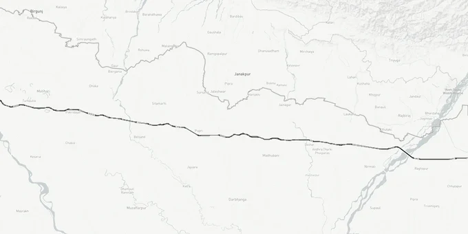
Gorakhpur - Siliguri Expressway
Gorakhpur Siliguri Expressway Preview
Try the Gorakhpur - Siliguri Expressway on the map
Sign in once and explore the layer for a full day.
- No card details needed
- Find nearby verified lands for sale
Overview
The Gorakhpur-Siliguri Expressway is a 525.5-km greenfield corridor under Bharatmala Pariyojana, connecting Gorakhpur in Uttar Pradesh to Siliguri in West Bengal through nine Bihar districts. NHAI (National Highways Authority of India) is the executing authority; LN Malviya Infra Projects prepared the DPR. Gazette notifications for land acquisition are active across all three states. Bihar tenders were floated in September 2025. Full-scale construction is expected to commence 2026 across Bihar packages. Phase 1 (UP to Bihar border) is furthest advanced. Target completion remains 2028. This Premium layer on 1acre maps the alignment as submitted in the DPR. Use it to verify whether a plot sits inside or outside the notified corridor before any transaction.
A route revision in October 2025 incorporated a 72 km stretch through Kishanganj district. Buyers near Kishanganj must verify their khasra number against the revised alignment — not the original DPR — before any transaction.
NHAI Gazette Notifications and the ROW Trap for Gorakhpur Siliguri Expressway Land Purchases
The Right of Way for this expressway is 100 meters. That band is under compulsory acquisition under the National Highways Act, 1956. In Bihar, NHAI has formally gazetted acquisition across four districts as the first wave. In Uttar Pradesh, acquisition began in May 2022 across 111 villages in Gorakhpur, Deoria, and Kushinagar. Any plot inside this corridor is not a purchase; it becomes a government compensation claim at rates assessed by the District Land Acquisition Officer.
The table below shows what the notified NHAI DPR alignment corridor covers across each state:
State
Stretch
Districts in ROW
ROW Width
Acquisition Status
Uttar Pradesh
84.3 km
Gorakhpur, Deoria, Kushinagar
60-100 m
Active since May 2022
Bihar
~417 km
W. Champaran, E. Champaran, Sheohar, Sitamarhi, Madhubani, Supaul, Araria, Kishanganj
100 m
NHAI Gazette issued
West Bengal
~19 km
Darjeeling (Siliguri)
100 m
Under process
The most consequential problem for buyers is this: NHAI has not published the DPR alignment map online. There is no downloadable, village-level survey map on any official NHAI portal. Brokers selling plots in Sitamarhi, Darbhanga, or Kushinagar as "adjacent to the expressway" cannot confirm whether a specific khasra number falls inside or outside the 100-meter notified band without an official Section 3D notice under the National Highways Act. Approximately 87.5 percent of all land being acquired is agricultural, and once a gazette notification is served on a survey number, that land cannot be legally resold by the original owner. Cross-check the 1acre alignment layer against your plot's coordinates and demand the Section 3D notice before signing any agreement.
Gorakhpur to Siliguri Expressway Corridor: Which Districts Hold Real Land Value and Which Are Speculative
The alignment runs through agricultural territory parallel to the India-Nepal border. The opportunity outside the ROW is real, but the timeline is not confirmed. Construction has not commenced on most Bihar packages as of 2025. Buying farmland in Supaul or Forbesganj based on a 2028 opening is a speculative position; the Kushinagar and Gorakhpur stretches in UP, where acquisition is furthest along, carry the most credible near-term signal.
The following table covers the principal micro-markets along the Gorakhpur Siliguri Expressway route and what each district offers for land buyers:
District / Locality
State
Connectivity Gain
Land Market Signal
Gorakhpur (Chaurichaura tehsil)
UP
Junction with NH-27 and Purvanchal network
Near-term; infrastructure active
Kushinagar (Hata, Tamukhiraj tehsils)
UP
Tourism corridor plus expressway intersection
Land-use change possible; monitor
Deoria
UP
Entry point to Bihar stretch
Agricultural base; limited near-term driver
Darbhanga
Bihar
Breaks isolation of Mithila belt
High speculative interest; no construction yet
Sitamarhi
Bihar
Near Nepal border; cross-border trade benefit
Early stage; long horizon
Forbesganj, Kishanganj
Bihar
Bihar-Bengal junction
Undeveloped; high-risk for short-term buyers
Siliguri (Darjeeling district)
West Bengal
Existing trade hub; expressway terminus
Established market; incremental uplift only
Darbhanga draws the most investor attention in current coverage, and for logical reasons: the Mithila belt has been connectivity-starved for decades. But that same logic has been used to sell speculative farmland there for two years before a single package goes to construction. The Kushinagar and Deoria exits are closer to confirmed activity and connect into the broader UP expressway network, making them the more grounded choice for buyers who need a shorter investment window.
Was this layer helpful?
Anything wrong, outdated, or missing we want to hear it.
For Land Owners & Agents
Looking to sell your land in Uttar Pradesh?
I want to sell my land in Uttar Pradesh
10:32
Plz share your Land's location - We will list it on 1acre map, for Free.
10:32

For Land Buyers
Browse all verified lands & plots in Uttar Pradesh
Every listing goes through our Preliminary Verification Process.
More Layers in Uttar Pradesh
See all 32 layers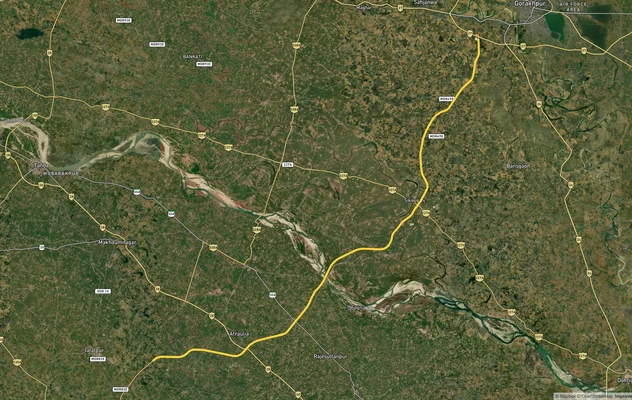
Gorakhpur Link Expressway
View the Gorakhpur Link Expressway corridor on a live map overlay – check zoning, approvals and acquisition risk free on...
Ayodhya Masterplan
View Ayodhya Masterplan as a live map overlay – check any plot's land use zone for free on 1acre.in. Ayodhya masterplan ...
Lucknow Masterplan
View Lucknow Masterplan as a live map overlay – check any plot's land use zone for free on 1acre.in. Lucknow masterplan ...
More Layers in Uttar Pradesh
Gorakhpur Link Expressway
View the Gorakhpur Link Expressway corridor on a live map overlay – check zoning, approvals and acquisition risk free on...
Ayodhya Masterplan
View Ayodhya Masterplan as a live map overlay – check any plot's land use zone for free on 1acre.in. Ayodhya masterplan ...
Lucknow Masterplan
View Lucknow Masterplan as a live map overlay – check any plot's land use zone for free on 1acre.in. Lucknow masterplan ...