Ayodhya Masterplan
Ayodhya Masterplan Preview
Try the Ayodhya Masterplan on the map
Sign in once and explore the layer for a full day.
- No card details needed
- Find nearby verified lands for sale
Overview
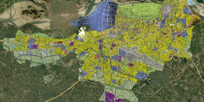
The ADA Master Plan 2031 is the operative zoning document governing all land use within Ayodhya's 133.67 sq km development area. Implemented in 2022 and valid through 2031, it divides the city into 18 zones covering residential (52.56%), commercial (5.11%), industrial (4.65%), public use (10.28%), transport (12.20%), and green open spaces (14.31%). Building heights across most zones are capped at 17.5 metres, with exceptions only for religious structures. This page explains the specific Ayodhya masterplan land zone traps, the corridors worth watching, and exactly how to use 1acre tools to verify a parcel before committing funds.
ADA Zone Check Failures: The Illegal Plotting Problem Unique to Ayodhya
Ayodhya has a documented and specific land fraud problem that no other Indian masterplan city faces to the same degree. Since the Ram Mandir verdict in 2019, demand for land near the temple complex exploded. The ADA itself identified 40 locations in the city where private parties had bought large tracts and subdivided them without obtaining the mandatory ADA map approval. Between 1,000 and 1,200 formal notices have been issued, and ADA bulldozers have already cleared illegal structures in areas including Bag Bijaisi, Tarapur Rajauli-Gaura Patti, Banbirpur, and Majha Kalan.
The fraud goes deeper than plotting violations. The state revenue department has officially listed eight survey villages along the Saryu River, including Manjha Jamthara, Manjha Mirapur, Manjha Baratha, and Rampur Halwara, for which land records are not available online. Any transaction in these survey villages requires manual verification with the local Lekhpal. Investors have already been duped here: a trust linked to a major spiritual organisation paid approximately ₹10 crore for land whose ownership documents were forged, with the mutation application subsequently rejected by a local court.
One more trap specific to Ayodhya: land in Majha Jamthara was notified as an army buffer zone under the Manoeuvres, Field Firing and Artillery Practice Act, 1938, covering 13,391 acres across 14 villages. Construction and commercial activity on such notified land is restricted. Although 2,211 acres in Majha Jamthara were de-notified in May 2024, the de-notification process itself is currently sub-judice before the Allahabad High Court. Buying land in the remaining 13 notified villages without verifying the current army notification status is a serious regulatory risk.
The table below summarises the three main red flags a buyer must clear before proceeding.
Risk Type
Specific Trigger
What to Check
Illegal plotting
ADA map approval was not obtained before the subdivision
Confirm ADA map approval exists for the plot
Survey village fraud
8 Saryu river survey villages, records not online
Manually verify with the local Lekhpal before any payment
Army buffer zone
13,391 acres across 14 villages notified under the 1938 Act
Check current notification status; Majha Jamthara de-notification is sub-judice
No broker in Ayodhya will proactively flag these three issues. If the ADA map approval number is not in the documents, walk away.
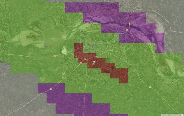
Ayodhya's Real Growth Corridors: Ring Road, Airport Road, and Parikrama Marg
Not every part of Ayodhya carries equal upside. Three corridors stand out as genuinely plan-backed, versus speculative or encumbered areas.
The ADA Master Plan 2031 explicitly reserves industrial corridors on both sides of the ring road. This is plan-confirmed, not broker speculation. Land within proximity to the ring road benefits directly from this designation. The Ayodhya-Lucknow highway corridor (NH-27) is the second high-conviction zone, anchored by the airport at Deokali and the Vasistha Kunj residential township, both of which are active ADA-developed projects. The Panchkosi and 14 Kosi Parikrama Marg is the third corridor: CM Yogi Adityanath has directed ADA to reserve land along both parikrama routes for religious tourism infrastructure, making these stretches directly linked to government capital deployment.
The table below maps corridor quality to plan backing.
Corridor
Plan Backing
Primary Use Classification
Risk Level
Ring Road (both sides)
Master Plan 2031 Industrial Reserve
Industrial / Mixed Use
Low (plan-confirmed)
Airport Road, Deokali
Active ADA township + RERA projects
Residential R-zone
Low
Panchkosi / 14 Kosi Parikrama Marg
CM-directed land reservation
Religious tourism / Public Use
Medium (implementation pending)
Bag Bijaisi / inner city fringe
The illegal plotting crackdown is active
Mixed, contested
High
Saryu Riverfront Villages
Survey village offline records + army buffer risk
Ecologically sensitive
Very High
The most misunderstood corridor is the Saryu riverfront, which carries the highest buyer enthusiasm and the highest documented risk. The combination of offline revenue records, army buffer notifications, and active High Court litigation makes it the one area where premium prices reflect speculation, not plan certainty.
Was this layer helpful?
Anything wrong, outdated, or missing we want to hear it.
For Land Owners & Agents
Looking to sell your land in Uttar Pradesh?
I want to sell my land in Uttar Pradesh
10:32
Plz share your Land's location - We will list it on 1acre map, for Free.
10:32

For Land Buyers
Browse all verified lands & plots in Uttar Pradesh
Every listing goes through our Preliminary Verification Process.
More Layers in Uttar Pradesh
See all 32 layers
Ayodhya Ring Road
View Ayodhya Ring Road alignment as a live map overlay – check land acquisition risk and plot proximity free on 1acre.in...
Ayodhya Air Funnel Zones
View Ayodhya Air Funnel Zones on a live map – check height clearance restrictions on any plot for free on 1acre.in. Ayod...
Lucknow Masterplan
View Lucknow Masterplan as a live map overlay – check any plot's land use zone for free on 1acre.in. Lucknow masterplan ...
More Layers in Uttar Pradesh
Ayodhya Ring Road
View Ayodhya Ring Road alignment as a live map overlay – check land acquisition risk and plot proximity free on 1acre.in...
Ayodhya Air Funnel Zones
View Ayodhya Air Funnel Zones on a live map – check height clearance restrictions on any plot for free on 1acre.in. Ayod...
Lucknow Masterplan
View Lucknow Masterplan as a live map overlay – check any plot's land use zone for free on 1acre.in. Lucknow masterplan ...