Ganga Expressway
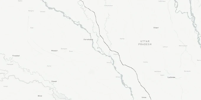
Ganga Expressway Preview
Try the Ganga Expressway on the map
Sign in once and explore the layer for a full day.
- No card details needed
- Find nearby verified lands for sale
Overview
Kanpur Ganga Expressway land buying has surged since PM Modi inaugurated the 594 km Meerut-to-Prayagraj corridor on April 29, 2026. The expressway passes through Unnao district, Kanpur's border district, positioning Kanpur as a central node across multiple corridors including the Agra-Lucknow and Awadh Expressways. The governing authority is UPEIDA (Uttar Pradesh Expressways Industrial Development Authority). For plots within Kanpur's urban planning boundary, KDA (Kanpur Development Authority) Masterplan 2031 applies across 1,484 sq km. This layer, available on 1acre Premium, overlays the expressway alignment, KDA zone boundaries, and survey number maps to let you verify any parcel before a site visit.
Kanpur's Expressway Land Trap: Two Approvals, One Dangerous Confusion
The single most exploited gap in Kanpur's fringe land market is the Zila Panchayat versus KDA approval distinction. Sellers of plots in villages near the Unnao interchange routinely show a Zila Panchayat sanction as proof the layout is legal. It is not the same as KDA approval. Zila Panchayat governs rural areas outside KDA's jurisdiction. KDA Masterplan 2031 governs Kanpur's 1,484 sq km planning area. A plot can hold a Zila Panchayat layout stamp and still sit inside an Industrial or Green zone under the KDA plan, making any residential construction illegal. The second trap is UPEIDA's acquisition power. UPEIDA has already banned all land sales in notified villages along the Ganga-Yamuna Link Expressway corridor (56 villages, July 2025 order). The same mechanism applies if UPEIDA notifies any spur or industrial node near Kanpur. Buying after notification is issued means your title transfers but UPEIDA acquires the land at circle rate, not market rate.
The table below maps the key zone categories under KDA Masterplan 2031 and what each means for a buyer near the expressway corridor.
Zone Type
Share of Planning Area
Permitted Use
Buyer Risk
Residential
36.62%
Housing, plotted development
Safe if KDA layout is sanctioned
Industrial
8.86%
Manufacturing, warehousing
Residential construction prohibited
Traffic and Transport
12.75%
Roads, right-of-way
Cannot be privately developed
Parks and Open Space
18.89%
Public green
No construction permitted
Commercial
2.90%
Retail, offices
Requires separate KDA commercial sanction
Before you sign anything near the Kanpur-Unnao fringe, pull the survey number on the 1acre Premium map. If the parcel sits in an Industrial or Transport zone under KDA Masterplan 2031, no Zila Panchayat stamp changes that fact.
Kanpur Growth Corridors: Where the Expressway Actually Moves Land Values
Not every plot marketed as "Ganga Expressway-adjacent" in Kanpur carries the same value driver. The Unnao interchange belt is the strongest near-Kanpur node because the expressway passes through Unnao district, and Unnao directly borders Kanpur Nagar. Government plans for pharma parks, textile parks, and IT parks are explicitly mapped to Meerut, Badaun, Kanpur, Varanasi, and Prayagraj under the expressway's industrial corridor programme. Kanpur's centrality across the Agra-Lucknow, Awadh, and Ganga Expressway networks makes industrial-zoned land near interchange points the highest-confidence category.
The table below classifies the corridors most frequently searched on 1acre near Kanpur in the context of Ganga Expressway land investment.
Corridor
Proximity to Expressway
Land Use Driver
Key Risk
Unnao-Kanpur border belt
Direct: expressway passes through Unnao
Industrial corridor, pharma/textile hubs
UPEIDA acquisition if notified
Bithoor Road / Chaubepur
15-25 km from alignment
Residential fringe expansion
KDA zone mismatch, Zila Panchayat confusion
Mandhana
Within KDA planning area
Residential, plotted development
Confirm KDA layout sanction before purchase
Banthra / Shuklaganj
Lucknow-Kanpur Expressway node
Logistics, warehousing
Verify if industrial zone under KDA plan
The most misread corridor is Chaubepur. Brokers market it as an expressway-appreciation zone. It is a residential fringe area within KDA's planning boundary and has no direct interchange with the Ganga Expressway. Appreciation here is driven by Kanpur's organic outward growth, not expressway proximity. Paying an "expressway premium" for Chaubepur plots without confirming the KDA zone classification is a pricing mistake, not an investment thesis.
Was this layer helpful?
Anything wrong, outdated, or missing we want to hear it.
For Land Owners & Agents
Looking to sell your land in Uttar Pradesh?
I want to sell my land in Uttar Pradesh
10:32
Plz share your Land's location - We will list it on 1acre map, for Free.
10:32

For Land Buyers
Browse all verified lands & plots in Uttar Pradesh
Every listing goes through our Preliminary Verification Process.
More Layers in Uttar Pradesh
See all 32 layers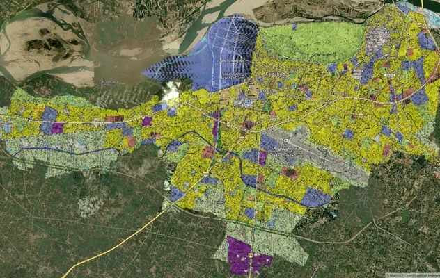
Ayodhya Masterplan
View Ayodhya Masterplan as a live map overlay – check any plot's land use zone for free on 1acre.in. Ayodhya masterplan ...
Lucknow Masterplan
View Lucknow Masterplan as a live map overlay – check any plot's land use zone for free on 1acre.in. Lucknow masterplan ...
Varanasi Masterplan
View Varanasi Masterplan as a live map overlay – check any plot's land use zone for free on 1acre.in. VDA Master Plan 20...
More Layers in Uttar Pradesh
Ayodhya Masterplan
View Ayodhya Masterplan as a live map overlay – check any plot's land use zone for free on 1acre.in. Ayodhya masterplan ...
Lucknow Masterplan
View Lucknow Masterplan as a live map overlay – check any plot's land use zone for free on 1acre.in. Lucknow masterplan ...
Varanasi Masterplan
View Varanasi Masterplan as a live map overlay – check any plot's land use zone for free on 1acre.in. VDA Master Plan 20...