Ghazipur - Ballia Expressway
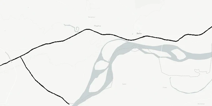
Ghazipur Ballia Expressway Preview
Try the Ghazipur - Ballia Expressway on the map
Sign in once and explore the layer for a full day.
- No card details needed
- Find nearby verified lands for sale
Overview
The Ghazipur Ballia Expressway land corridor is a 132.76-kilometre four-lane greenfield access-controlled highway built by NHAI (National Highways Authority of India) and UPEIDA (Uttar Pradesh Expressways Industrial Development Authority), starting near Hridaypur village on NH-29 in Ghazipur district and ending at Bahoran Tola village on the Uttar Pradesh-Bihar border at Manjhighat on NH-31. It includes a 17.27-km Buxar spur connecting to Bihar. Built at a project cost of approximately Rs 3,200 crore plus Rs 1,100 crore for the Manjhighat bridge, the corridor traverses Ghazipur and Ballia districts in UP and Saran district in Bihar. As of February 2026, construction was 84% complete, but packages 2 and 3 were significantly behind package 1. The June 2026 opening target has passed without inauguration. INI estimated 12-15 more months from July 2025, pointing to a late-2026 opening at the earliest.
What Buyers Near the Ghazipur Ballia Corridor Must Verify Before Signing
Construction was 84% complete as of February 2026, but the June 2026 opening target has passed without inauguration. A revised NHAI target is pending. That proximity to inauguration is the most dangerous moment to buy agricultural land near any expressway: prices peak on completion speculation, verification drops, and the actual ROW boundary has been fixed for years. Several specific risks are active on this corridor that generic corridor guidance misses.
The first is river floodplain overlap. The EAC (Environmental Appraisal Committee) environmental clearance documents confirm that the Ghagra River and Tamsa River cross the alignment directly. The Ganga River flows alongside the alignment in the Ballia section, and the Ghagra crosses near Manjhighat. Any agricultural plot within the seasonal floodplain of either river that also sits adjacent to the expressway alignment carries two independent restrictions: the NHAI Right of Way buffer and the floodplain development prohibition under environmental clearance conditions. Brokers rarely disclose both simultaneously.
The second is the 822-hectare acquisition boundary. As of October 2024, NHAI and UPEIDA had acquired 744 of 822.05 hectares. That means approximately 78 hectares remained unacquired at that date, distributed across Ghazipur and Ballia districts. Any parcel in the 16 named villages that had not yet completed acquisition was still subject to compulsory acquisition at NHAI-assessed rates.
The table below maps each risk category by package zone.
Risk Zone
District
Specific Risk
Verification Step
Package 1, Hridaypur to Ghazipur section
Ghazipur
Unacquired parcels in 78-hectare residual from 822-hectare acquisition
Cross-check plot khasra against UPEIDA acquisition records at Ghazipur district office
Package 2, Shahpur to Pindari section
Ballia
Active construction reported as of mid-2026; ROW disturbance near named villages
Confirm no Section 3A notice issued against the plot
Ganga river alignment stretch
Ballia
Floodplain and river-course-adjacent land; EAC conditions restrict development
Verify plot elevation and flood-plain status before purchasing
Ghagra river crossing, Manjhighat end
Ballia / Bihar border
Bridge approach ROW and Bihar border proximity restrict land use
Confirm plot is outside bridge ROW buffer; check UP-Bihar boundary jurisdiction
The named 16 villages in the alignment are Badhwalia, Shahapur, Lakda, Avgilwa, Hardarpur, Bankapur, Tikri, Sareh-Ijra, Basaratpur, Sultanpur, Rasda, Kotwari, Kuruchanda Singhpur, Pura Ekouni, Ekouni, and Pah Teekha. If a broker is showing you agricultural land in any of these villages, the starting question is whether it sits inside or outside the acquired 744-hectare boundary. Do not assume "outside" without the khasra verification.
Where Real Demand Will Build Along the Ghazipur Ballia Corridor
The Ghazipur Ballia Expressway completes the last missing link in UP's eastern expressway network. Once open, it connects Ballia, UP's easternmost district, to the Purvanchal Expressway at Haydaria village in Ghazipur, creating a continuous access-controlled corridor from Lucknow all the way to the Bihar border. That is a freight and passenger volume story, not a residential story, at least for the next four to six years.
Two nodes carry the most concrete demand. The first is the junction with the Purvanchal Expressway in Ghazipur. The 24-km link road connecting the two expressways means the Ghazipur junction sits at the convergence of three traffic flows: Lucknow to Delhi via Agra-Lucknow Expressway, eastern UP traffic on the Purvanchal Expressway, and the new Ballia corridor traffic heading toward Bihar. Warehousing and logistics will fill that node before any residential development arrives. The second is the Buxar spur, a 17.27-km connection from the main corridor to Buxar in Bihar. Land within 2 km of the spur terminus near Buxar will attract cross-border freight movement and has genuine commercial demand rationale.
The table below gives the realistic investment profile for each corridor pocket.
Corridor Pocket
District
Demand Type
Realistic Timeline
Key Risk
Purvanchal Expressway junction, Ghazipur
Ghazipur
Logistics, warehousing, freight village
3-5 years
Confirm outside NHAI acquisition boundary and IMLC industrial land notifications
Shahpur to Pindari belt, Ballia
Ballia
Agricultural corridor, mid-distance hold
5-7 years
Package 2 construction active; ROW disturbance ongoing
Ballia-Manjhighat end near NH-31
Ballia
Bihar border trade, logistics
5-7 years
Ghagra river floodplain overlap; bridge ROW buffer
Buxar spur corridor, Saran district
Bihar
Cross-border freight, industrial
6-9 years
Bihar jurisdiction; UP expressway law does not apply here
The Buxar spur is the most misread pocket. Brokers market land near the spur as "part of the Ballia Link Expressway" zone, which creates an impression of full UP expressway governance. The spur terminus is in Saran district, Bihar. Bihar land laws and acquisition frameworks apply there, not UP's. Any land transaction near the Buxar end requires Bihar district revenue records verification, not UP-based checks.
Was this layer helpful?
Anything wrong, outdated, or missing we want to hear it.
For Land Owners & Agents
Looking to sell your land in Uttar Pradesh?
I want to sell my land in Uttar Pradesh
10:32
Plz share your Land's location - We will list it on 1acre map, for Free.
10:32

For Land Buyers
Browse all verified lands & plots in Uttar Pradesh
Every listing goes through our Preliminary Verification Process.
More Layers in Uttar Pradesh
See all 32 layers
Ayodhya Masterplan
View Ayodhya Masterplan as a live map overlay – check any plot's land use zone for free on 1acre.in. Ayodhya masterplan ...
Lucknow Masterplan
View Lucknow Masterplan as a live map overlay – check any plot's land use zone for free on 1acre.in. Lucknow masterplan ...
Varanasi Masterplan
View Varanasi Masterplan as a live map overlay – check any plot's land use zone for free on 1acre.in. VDA Master Plan 20...
More Layers in Uttar Pradesh
Ayodhya Masterplan
View Ayodhya Masterplan as a live map overlay – check any plot's land use zone for free on 1acre.in. Ayodhya masterplan ...
Lucknow Masterplan
View Lucknow Masterplan as a live map overlay – check any plot's land use zone for free on 1acre.in. Lucknow masterplan ...
Varanasi Masterplan
View Varanasi Masterplan as a live map overlay – check any plot's land use zone for free on 1acre.in. VDA Master Plan 20...