Ahilyanagar - Akalkot Expressway
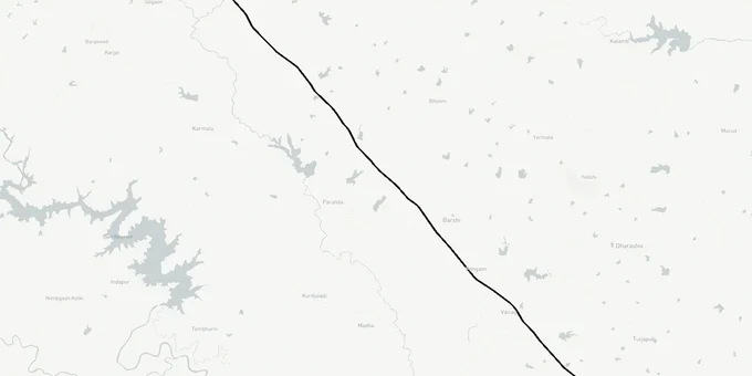
Ahilyanagar Akalkot Expressway Preview
Try the Ahilyanagar - Akalkot Expressway on the map
Sign in once and explore the layer for a full day.
- No card details needed
- Find nearby verified lands for sale
Overview
The Surat-Chennai Expressway (Ahilyanagar-Akkalkot Section) is a 222-km, six-lane greenfield corridor under NH-150C (National Highway 150C), forming part of the 374-km Nashik-Akkalkot project approved by the Cabinet Committee on Economic Affairs on 31 December 2025 at a cost of ₹19,142 crore. The DPR was prepared by Aarvee Associates-Nag Infrastructure Engineers and Consultant JV. Land acquisition is in an advanced stage: Section 3A notifications cover roughly 90% of the route, passing through Ahilyanagar, Beed, Dharashiv and Solapur districts. This page covers the acquisition risks, investable corridors, and what to verify before buying land near this alignment.
Fake Alignment Maps and Section 3A Traps: The Two Risks Buyers in Ahilyanagar Miss
Plots near proposed greenfield alignments in Maharashtra carry two distinct risks that experienced buyers treat as separate problems, not one.
The first is the acquisition zone risk. Under Section 3A of the National Highways Act, 1956, once a gazette notification is published, any land within the notified strip vests in NHAI (National Highways Authority of India) at the time of the Section 3D declaration, regardless of who purchased it after the notification date. With roughly 90% of Section 3A notifications already issued and around 80% of Section 3D declarations completed along the Nashik-Akkalkot corridor as of January 2026, a buyer who acquires a plot within the notified belt today is purchasing a parcel the government has already claimed. Compensation is awarded at the market rate as of the Section 3A notification date, not the price you paid.
The second risk is fake alignment fraud. Across India, unscrupulous brokers circulate unofficial maps, sometimes on WhatsApp, showing proposed expressway alignments passing through plots they are trying to sell. The Gujarat High Court recently cancelled a land acquisition on the Ahmedabad-Dholera Expressway after finding coordination between private landowners and officials to misuse the acquisition process. The same pattern applies in reverse: fabricated route maps are used to inflate plot prices near alignments that have no official DPR basis.
Before you sign anything near this corridor, ask the seller for the official survey number and cross-reference it against the Section 3A gazette notification for NH-150C on the NHAI or Ahilyanagar district collector's website. If they cannot produce that match, the plot is either inside the acquisition strip or the alignment claim is unverified.
The table below shows the current acquisition status along the Ahilyanagar-Akkalkot section.
Acquisition Stage
Section
Status (as of Jan 2026)
Section 3A, Intent to Acquire
~90% of route
Notified
Section 3D, Vesting Declaration
~80% of route
Issued
Section 3G, Compensation Award
~40% of route
Completed
Construction start
BOT model, tenders pending
Awaiting construction commencement
Acquisition Stage
Section
Status (as of Jan 2026)
Section 3A, Intent to Acquire
~90% of route
Notified
Section 3D, Vesting Declaration
~80% of route
Issued
Section 3G, Compensation Award
~40% of route
Completed
Construction start
BOT model, tenders pending
Awaiting construction commencement
Any plot inside the notified corridor at the Section 3D stage has legally vested in NHAI. Purchasing it does not transfer the compensation entitlement, that remains with the landowner named at the time of the Section 3A notification.
Investable Corridors in Ahilyanagar: Where the Expressway Creates Value Without the Acquisition Risk
The Nashik-Ahilyanagar section spans 152 km with a 70-metre right-of-way, while the Ahilyanagar-Akkalkot section covers 222 km with a 60-metre ROW. The value opportunity for investors is not inside those widths, it is on the periphery, near interchange nodes.
The expressway passes through Nashik, Ahilyanagar, Beed, Dharashiv and Solapur districts. It connects to the Samruddhi Mahamarg at Pangri (near Nashik) and to the Agra-Mumbai corridor at the NH-60 junction near Adgaon. These interchange-adjacent zones in Ahilyanagar are where freight, logistics and agri-processing demand typically accumulates, not at random plots along a bypass.
The project is expected to reduce Nashik-Akkalkot travel time from nine hours to four, and the Surat-Chennai overall travel time by approximately 17 hours while saving 201 km of distance. That is a genuine economic shift for the corridor, though the 3-year construction period from construction commencement means appreciation timelines are medium-term, not immediate.
The table below outlines the corridor's investable zones with their principal risk factor.
Zone
Type
Growth Driver
Key Risk
Pangri / Nashik fringe
Interchange node
Samruddhi Mahamarg connectivity
Speculative pricing already elevated
Ahilyanagar district (non-acquisition strip)
Agricultural / logistics
Expressway throughput, NICDC (National Industrial Corridor Development Corporation) node links
Acquisition boundary not yet demarcated for all villages
Solapur-Akkalkot fringe
Agricultural
Kurnool connectivity, freight corridor
Corridor still under Section 3A process in patches
The most misunderstood investment in this corridor is a plot inside the acquisition notified area, purchased because a broker shows a "copy" of the DPR route. The official DPR was prepared for regulatory approvals, not for retail broker distribution. Verify the survey number against the official gazette before treating any proximity claim as an investment thesis.
Was this layer helpful?
Anything wrong, outdated, or missing we want to hear it.
For Land Owners & Agents
Looking to sell your land in Maharashtra?
I want to sell my land in Maharashtra
10:32
Plz share your Land's location - We will list it on 1acre map, for Free.
10:32

For Land Buyers
Browse all verified lands & plots in Maharashtra
Every listing goes through our Preliminary Verification Process.
More Layers in Maharashtra
See all 32 layers
Mumbai Development Plan 2034: Zone Check and Land Use Guide
View Mumbai Masterplan as a live map overlay – check any plot's land use zone for free on 1acre.in. Mumbai masterplan 20...
Nagpur Masterplan 2032: Zone Check and Land Use Guide
View Nagpur Masterplan as a live map overlay – check any plot's land use zone for free on 1acre.in. Nagpur Metropolitan ...
Pimpri Chinchwad PCMC Masterplan: Zone Check and Land Use Guide
View Pimpri Chinchwad Masterplan as a live map overlay – check any plot's land use zone for free on 1acre.in. Pimpri Chi...
More Layers in Maharashtra
Mumbai Development Plan 2034: Zone Check and Land Use Guide
View Mumbai Masterplan as a live map overlay – check any plot's land use zone for free on 1acre.in. Mumbai masterplan 20...
Nagpur Masterplan 2032: Zone Check and Land Use Guide
View Nagpur Masterplan as a live map overlay – check any plot's land use zone for free on 1acre.in. Nagpur Metropolitan ...
Pimpri Chinchwad PCMC Masterplan: Zone Check and Land Use Guide
View Pimpri Chinchwad Masterplan as a live map overlay – check any plot's land use zone for free on 1acre.in. Pimpri Chi...