Mumbai Nagpur Samruddhi Mahamarg
Mumbai Nagpur Samruddhi Mahamarg Preview
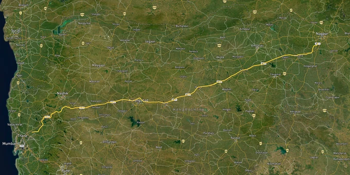
Try the Mumbai Nagpur Samruddhi Mahamarg on the map
Sign in once and explore the layer for a full day.
- No card details needed
- Find nearby verified lands for sale
Overview
The Mumbai-Nagpur Samruddhi Mahamarg (officially the Hindu Hrudaysamrat Balasaheb Thackeray Maharashtra Samruddhi Mahamarg, Maharashtra Expressway-2) became fully operational on 5 June 2025, when the final 76 km Igatpuri-Amane stretch opened. The 701 km, 6-lane access-controlled expressway built by MSRDC at ₹55,335 crore passes through 10 districts and 392 villages across Nagpur, Wardha, Amravati, Washim, Buldhana, Jalna, Aurangabad, Ahmednagar, Nashik, and Thane. This page covers the agricultural land conversion trap, the Krushi Samruddhi Nagar township reality, and the three micro-markets where the expressway actually moves land values.
Agricultural Land and the NA Conversion Trap Along the Samruddhi Corridor
The Samruddhi Mahamarg is fully operational. That fact has triggered one of the most aggressive waves of agricultural land marketing in Maharashtra's recent history, and most of it skips the most consequential legal detail: a 7/12 extract showing non-agricultural status does not make a plot safe to build on, finance, or resell freely.
MSRDC's own acquisition documents reveal this clearly. The project encountered 34 hectares of non-agricultural land across Wardha, Jalna, Aurangabad, Ahmednagar, Nashik, and Thane districts, where NA status itself needed to be independently verified before any transaction. If MSRDC, with full government powers, had to verify NA status parcel by parcel, a retail buyer relying on a broker's word faces a harder problem. Along the Samruddhi corridor, agricultural land that sits outside the jurisdictions of NMRDA, NIT, or a local planning authority carries no guarantee of building permission, infrastructure provision, or bank loan eligibility, regardless of NA conversion status.
The table below shows the key document chain that separates a legally transactable plot from one that looks valid on paper but fails at registration or financing.
Document
What It Confirms
What It Does Not Confirm
7/12 Extract (Satbara Utara)
Ownership record and land use classification
Zone compliance, layout sanction, or building permission eligibility
NA Order (Non-Agricultural Conversion)
Agricultural use restriction removed by district collector.
NMRDA/NIT layout sanction; infrastructure provision; bank loan eligibility
NMRDA Layout Sanction
The plot is within an approved layout under NMRDA Master Plan 2032
That the RL (Release Letter) has been issued for the specific plot
Release Letter (RL)
Specific plot released from developer's mortgage to NMRDA after development works complete
Clear title if RL is absent, even if layout sanction exists
For plots near the Samruddhi corridor in Nagpur, the 1-acre Nagpur Masterplan layer shows zone classifications under the NMRDA Masterplan 2032 across 3,567 sq km and 721 villages. An agricultural zone designation on the master plan map means the NA conversion and the plot price the broker quotes are both irrelevant: no NMRDA layout sanction is possible on A1/A2 agriculture-zoned land without a prior zone change. If a broker cannot produce both the NMRDA layout sanction and the RL for your specific survey number, the purchase carries legal risk.
Nagpur, Nashik, and the Node Townships: Which Parts of the Corridor Are Actually Investment-Ready
The Samruddhi Mahamarg passes through 24 talukas and 392 villages. Three are genuinely investment-ready now. The rest are still waiting on an MSRDC township notification that has been reduced, delayed, and revised multiple times since the project's inception.
MSRDC was authorized as New Town Development Authority (NTDA) under Section 113 of the MR & TP Act, 1966, to develop 19 new townships, called Krushi Samruddhi Nagar, at strategic nodes along the route. Each was planned for 1,000–1,500 hectares and designed to host food processing industries, integrated logistics, and residential development. The original proposal was 24 nodes. It was revised to 17 and then to just 3 operational townships in Buldhana, Wardha, and Aurangabad, where land pooling cooperation from farmers was confirmed. Brokers marketing plots in mid-corridor villages on the basis of an “upcoming Krushi Samruddhi Nagar node” should be asked to show the MSRDC notification for that specific node. Most cannot.
The table below maps the three micro-markets where the investment case is grounded in confirmed infrastructure rather than node projections.
Micro-Market
Confirmed Infrastructure Anchor
Key Zone Status
Primary Buyer Risk
South Nagpur (Wardha Road, MIHAN, Jamtha, Butibori)
MIHAN SEZ operational, Nagpur International Airport, Samruddhi Mahamarg Nagpur terminus, NMRDA Masterplan 2032
NMRDA-sanction layouts available; Wardha Road plots ₹2,200–₹4,500/sq ft (Jan 2026)
Gram Panchayat and unsanctioned NA plots sold alongside legal NMRDA plots; verify RL before any purchase
Nashik (Igatpuri gateway, Bharvir interchange)
The final Igatpuri-Amane stretch inaugurated June 2025; direct Mumbai connectivity now confirmed
Mix of NIT-governed and agricultural fringe zones
Agricultural land beyond NIT jurisdiction misrepresented as interchange-adjacent investment land
Aurangabad / Chhatrapati Sambhajinagar (Krushi Samruddhi Nagar Aurangabad node)
One of three confirmed operational MSRDC township nodes; State Warehousing Corporation township development approved
Industrial and mixed-use node designation; MIDC industrial zone active
Node development proceeding slowly; timeline for residential plots in township is not fixed
The most misunderstood micro-market is the mid-corridor agricultural belt between Washim, Buldhana, and Jalna. Sellers price land in these talukas on the basis of Samruddhi proximity, but the expressway is access-controlled, meaning there are no interchanges in most of these villages. Confirm the nearest interchange location from the MSRDC project map before paying any advance. Being three kilometers from the expressway tarmac and fifteen kilometers from the nearest interchange are two completely different investment propositions.
Was this layer helpful?
Anything wrong, outdated, or missing we want to hear it.
For Land Owners & Agents
Looking to sell your land in Maharashtra?
I want to sell my land in Maharashtra
10:32
Plz share your Land's location - We will list it on 1acre map, for Free.
10:32

For Land Buyers
Browse all verified lands & plots in Maharashtra
Every listing goes through our Preliminary Verification Process.
More Layers in Maharashtra
See all 32 layers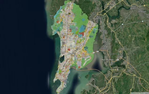
Mumbai Development Plan 2034: Zone Check and Land Use Guide
View Mumbai Masterplan as a live map overlay – check any plot's land use zone for free on 1acre.in. Mumbai masterplan 20...
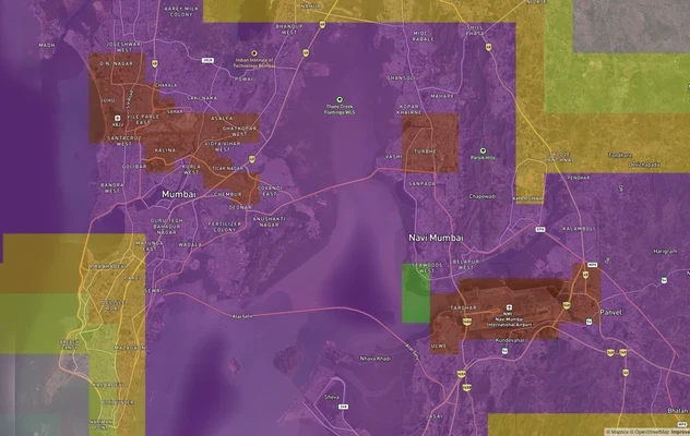
Mumbai Air Funnel Zones: Building Height Restrictions
View Mumbai Air Funnel Zones on a live map – check height clearance restrictions on any plot for free on 1acre.in. Mumba...
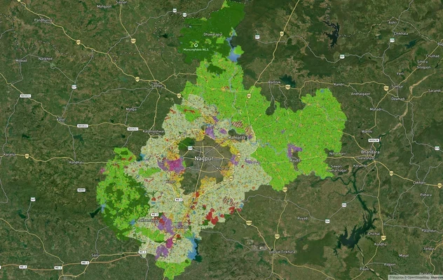
Nagpur Masterplan 2032: Zone Check and Land Use Guide
View Nagpur Masterplan as a live map overlay – check any plot's land use zone for free on 1acre.in. Nagpur Metropolitan ...
More Layers in Maharashtra
Mumbai Development Plan 2034: Zone Check and Land Use Guide
View Mumbai Masterplan as a live map overlay – check any plot's land use zone for free on 1acre.in. Mumbai masterplan 20...
Mumbai Air Funnel Zones: Building Height Restrictions
View Mumbai Air Funnel Zones on a live map – check height clearance restrictions on any plot for free on 1acre.in. Mumba...
Nagpur Masterplan 2032: Zone Check and Land Use Guide
View Nagpur Masterplan as a live map overlay – check any plot's land use zone for free on 1acre.in. Nagpur Metropolitan ...